You are here: Home > Network List > S1 - Australian Seismometers in Schools Stations List
> Station AUPHS Peel High School > Earthquake Result Viewer
AUPHS Peel High School - Earthquake Result Viewer
| Earthquake location: |
Philippine Islands Region |
| Earthquake latitude/longitude: |
5.0/127.5 |
| Earthquake time(UTC): |
2021/01/21 (021) 12:23:05 GMT |
| Earthquake Depth: |
96 km |
| Earthquake Magnitude: |
7.0 mww |
| Earthquake Catalog/Contributor: |
NEIC PDE/us |
|
| Network: |
S1 Australian Seismometers in Schools |
| Station: |
AUPHS Peel High School |
| Lat/Lon: |
31.10 S/150.89 E |
| Elevation: |
404 m |
|
| Distance: |
42.3 deg |
| Az: |
149.608 deg |
| Baz: |
324.016 deg |
| Ray Param: |
0.07295886 |
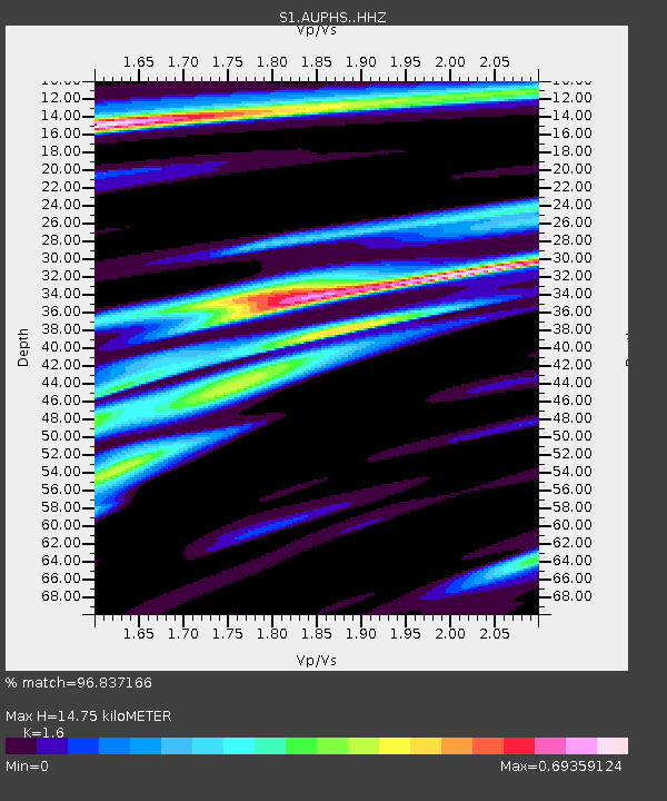
| Estimated Moho Depth: |
14.75 km |
| Estimated Crust Vp/Vs: |
1.60 |
| Assumed Crust Vp: |
6.577 km/s |
| Estimated Crust Vs: |
4.11 km/s |
| Estimated Crust Poisson's Ratio: |
0.18 |
|
| Radial Match: |
96.837166 % |
| Radial Bump: |
235 |
| Transverse Match: |
74.89912 % |
| Transverse Bump: |
400 |
| SOD ConfigId: |
23341671 |
| Insert Time: |
2021-02-04 13:36:57.441 +0000 |
| GWidth: |
2.5 |
| Max Bumps: |
400 |
| Tol: |
0.001 |
|

Signal To Noise
| Channel | StoN | STA | LTA |
| S1:AUPHS: :HHZ:20210121T12:30:19.400007Z | 16.703861 | 6.660465E-6 | 3.9873802E-7 |
| S1:AUPHS: :HHN:20210121T12:30:19.400007Z | 12.849963 | 3.3430092E-6 | 2.6015712E-7 |
| S1:AUPHS: :HHE:20210121T12:30:19.400007Z | 7.231448 | 2.2297163E-6 | 3.0833604E-7 |
| Arrivals |
| Ps | 1.5 SECOND |
| PpPs | 5.4 SECOND |
| PsPs/PpSs | 6.8 SECOND |


