You are here: Home > Network List > TA - USArray Transportable Network (new EarthScope stations) Stations List
> Station D19K Kuna River, AK, USA > Earthquake Result Viewer
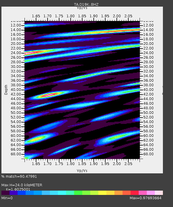
D19K Kuna River, AK, USA - Earthquake Result Viewer
| Earthquake location: |
Philippine Islands Region |
| Earthquake latitude/longitude: |
5.0/127.5 |
| Earthquake time(UTC): |
2021/01/21 (021) 12:23:05 GMT |
| Earthquake Depth: |
96 km |
| Earthquake Magnitude: |
7.0 mww |
| Earthquake Catalog/Contributor: |
NEIC PDE/us |
|
| Network: |
TA USArray Transportable Network (new EarthScope stations) |
| Station: |
D19K Kuna River, AK, USA |
| Lat/Lon: |
68.49 N/158.12 W |
| Elevation: |
671 m |
|
| Distance: |
79.7 deg |
| Az: |
21.159 deg |
| Baz: |
257.223 deg |
| Ray Param: |
0.048607416 |
| Estimated Moho Depth: |
24.0 km |
| Estimated Crust Vp/Vs: |
1.60 |
| Assumed Crust Vp: |
6.221 km/s |
| Estimated Crust Vs: |
3.882 km/s |
| Estimated Crust Poisson's Ratio: |
0.18 |
|
| Radial Match: |
90.47991 % |
| Radial Bump: |
400 |
| Transverse Match: |
81.59042 % |
| Transverse Bump: |
400 |
| SOD ConfigId: |
23341671 |
| Insert Time: |
2021-02-04 13:37:10.680 +0000 |
| GWidth: |
2.5 |
| Max Bumps: |
400 |
| Tol: |
0.001 |
|

Signal To Noise
| Channel | StoN | STA | LTA |
| TA:D19K: :BHZ:20210121T12:34:31.700025Z | 22.303118 | 6.012935E-6 | 2.6960066E-7 |
| TA:D19K: :BHN:20210121T12:34:31.700025Z | 5.941596 | 7.860619E-7 | 1.322981E-7 |
| TA:D19K: :BHE:20210121T12:34:31.700025Z | 9.44071 | 1.5231341E-6 | 1.6133681E-7 |
| Arrivals |
| Ps | 2.4 SECOND |
| PpPs | 9.7 SECOND |
| PsPs/PpSs | 12 SECOND |


