You are here: Home > Network List > TA - USArray Transportable Network (new EarthScope stations) Stations List
> Station H31M Peel River, Yukon, CAN > Earthquake Result Viewer
H31M Peel River, Yukon, CAN - Earthquake Result Viewer

| Earthquake location: |
Philippine Islands Region |
| Earthquake latitude/longitude: |
5.0/127.5 |
| Earthquake time(UTC): |
2021/01/21 (021) 12:23:05 GMT |
| Earthquake Depth: |
96 km |
| Earthquake Magnitude: |
7.0 mww |
| Earthquake Catalog/Contributor: |
NEIC PDE/us |
|
| Network: |
TA USArray Transportable Network (new EarthScope stations) |
| Station: |
H31M Peel River, Yukon, CAN |
| Lat/Lon: |
65.81 N/134.34 W |
| Elevation: |
642 m |
|
| Distance: |
88.8 deg |
| Az: |
24.084 deg |
| Baz: |
279.456 deg |
| Ray Param: |
0.04212656 |
| Estimated Moho Depth: |
41.75 km |
| Estimated Crust Vp/Vs: |
2.00 |
| Assumed Crust Vp: |
6.419 km/s |
| Estimated Crust Vs: |
3.218 km/s |
| Estimated Crust Poisson's Ratio: |
0.33 |
|
| Radial Match: |
81.68966 % |
| Radial Bump: |
400 |
| Transverse Match: |
60.103905 % |
| Transverse Bump: |
400 |
| SOD ConfigId: |
23341671 |
| Insert Time: |
2021-02-04 13:37:51.888 +0000 |
| GWidth: |
2.5 |
| Max Bumps: |
400 |
| Tol: |
0.001 |
|
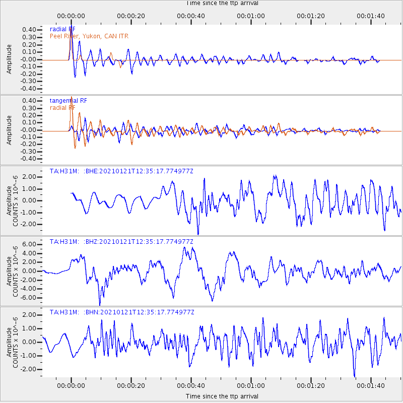
Signal To Noise
| Channel | StoN | STA | LTA |
| TA:H31M: :BHZ:20210121T12:35:17.774977Z | 6.455289 | 2.7144583E-6 | 4.2050144E-7 |
| TA:H31M: :BHN:20210121T12:35:17.774977Z | 1.3675213 | 5.8190443E-7 | 4.255176E-7 |
| TA:H31M: :BHE:20210121T12:35:17.774977Z | 2.1911504 | 1.0380497E-6 | 4.737464E-7 |
| Arrivals |
| Ps | 6.6 SECOND |
| PpPs | 19 SECOND |
| PsPs/PpSs | 26 SECOND |


