You are here: Home > Network List > TX - Texas Seismological Network Stations List
> Station ALPN Alpine > Earthquake Result Viewer
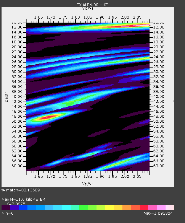
ALPN Alpine - Earthquake Result Viewer
| Earthquake location: |
Off East Coast Of Honshu, Japan |
| Earthquake latitude/longitude: |
37.5/144.0 |
| Earthquake time(UTC): |
2017/10/06 (279) 07:59:33 GMT |
| Earthquake Depth: |
10 km |
| Earthquake Magnitude: |
6.0 Mww |
| Earthquake Catalog/Contributor: |
NEIC PDE/us |
|
| Network: |
TX Texas Seismological Network |
| Station: |
ALPN Alpine |
| Lat/Lon: |
30.37 N/103.64 W |
| Elevation: |
1368 m |
|
| Distance: |
87.5 deg |
| Az: |
53.101 deg |
| Baz: |
312.6 deg |
| Ray Param: |
0.04324993 |
| Estimated Moho Depth: |
11.0 km |
| Estimated Crust Vp/Vs: |
2.10 |
| Assumed Crust Vp: |
6.121 km/s |
| Estimated Crust Vs: |
2.918 km/s |
| Estimated Crust Poisson's Ratio: |
0.35 |
|
| Radial Match: |
80.13589 % |
| Radial Bump: |
400 |
| Transverse Match: |
61.250145 % |
| Transverse Bump: |
400 |
| SOD ConfigId: |
2364251 |
| Insert Time: |
2017-10-20 08:06:54.352 +0000 |
| GWidth: |
2.5 |
| Max Bumps: |
400 |
| Tol: |
0.001 |
|

Signal To Noise
| Channel | StoN | STA | LTA |
| TX:ALPN:00:HHZ:20171006T08:11:49.575027Z | 2.1161263 | 5.9429226E-7 | 2.808397E-7 |
| TX:ALPN:00:HH1:20171006T08:11:49.575027Z | 1.6099765 | 1.8575696E-7 | 1.15378676E-7 |
| TX:ALPN:00:HH2:20171006T08:11:49.575027Z | 2.557978 | 3.1043157E-7 | 1.213582E-7 |
| Arrivals |
| Ps | 2.0 SECOND |
| PpPs | 5.5 SECOND |
| PsPs/PpSs | 7.5 SECOND |


