You are here: Home > Network List > TA - USArray Transportable Network (new EarthScope stations) Stations List
> Station J14K Nanvaranak Lake, AK, USA > Earthquake Result Viewer
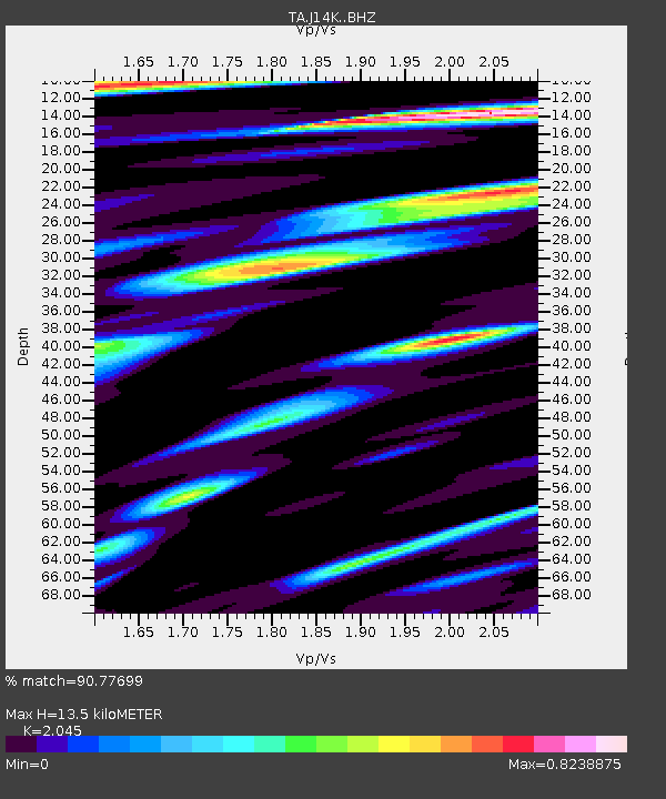
J14K Nanvaranak Lake, AK, USA - Earthquake Result Viewer
| Earthquake location: |
Philippine Islands Region |
| Earthquake latitude/longitude: |
5.0/127.5 |
| Earthquake time(UTC): |
2021/01/21 (021) 12:23:05 GMT |
| Earthquake Depth: |
96 km |
| Earthquake Magnitude: |
7.0 mww |
| Earthquake Catalog/Contributor: |
NEIC PDE/us |
|
| Network: |
TA USArray Transportable Network (new EarthScope stations) |
| Station: |
J14K Nanvaranak Lake, AK, USA |
| Lat/Lon: |
62.75 N/163.55 W |
| Elevation: |
25 m |
|
| Distance: |
76.0 deg |
| Az: |
26.275 deg |
| Baz: |
253.347 deg |
| Ray Param: |
0.051072955 |
| Estimated Moho Depth: |
13.5 km |
| Estimated Crust Vp/Vs: |
2.05 |
| Assumed Crust Vp: |
6.155 km/s |
| Estimated Crust Vs: |
3.01 km/s |
| Estimated Crust Poisson's Ratio: |
0.34 |
|
| Radial Match: |
90.77699 % |
| Radial Bump: |
400 |
| Transverse Match: |
78.92743 % |
| Transverse Bump: |
400 |
| SOD ConfigId: |
23341671 |
| Insert Time: |
2021-02-04 13:38:00.433 +0000 |
| GWidth: |
2.5 |
| Max Bumps: |
400 |
| Tol: |
0.001 |
|

Signal To Noise
| Channel | StoN | STA | LTA |
| TA:J14K: :BHZ:20210121T12:34:11.524977Z | 7.8799267 | 4.3927557E-6 | 5.574615E-7 |
| TA:J14K: :BHN:20210121T12:34:11.524977Z | 1.350791 | 6.5827663E-7 | 4.873268E-7 |
| TA:J14K: :BHE:20210121T12:34:11.524977Z | 3.1115236 | 1.3608288E-6 | 4.3735128E-7 |
| Arrivals |
| Ps | 2.3 SECOND |
| PpPs | 6.5 SECOND |
| PsPs/PpSs | 8.9 SECOND |


