You are here: Home > Network List > GE - GEOFON Stations List
> Station KBS IRIS/GEOFON/AWI Station Ny Alesund, Spitsbergen > Earthquake Result Viewer
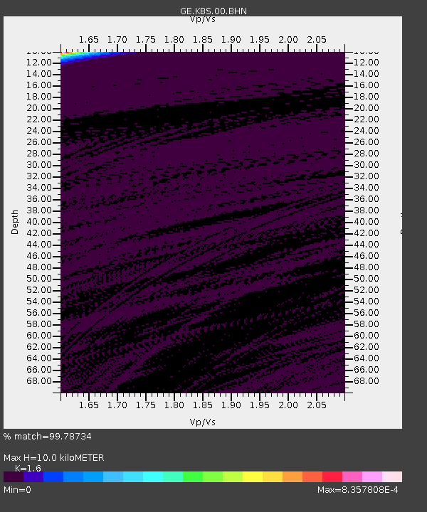
KBS IRIS/GEOFON/AWI Station Ny Alesund, Spitsbergen - Earthquake Result Viewer
| Earthquake location: |
Southern Iran |
| Earthquake latitude/longitude: |
28.1/56.9 |
| Earthquake time(UTC): |
2006/02/28 (059) 07:31:02 GMT |
| Earthquake Depth: |
18 km |
| Earthquake Magnitude: |
5.8 MB, 6.2 MS, 6.0 MW, 6.0 MW |
| Earthquake Catalog/Contributor: |
WHDF/NEIC |
|
| Network: |
GE GEOFON |
| Station: |
KBS IRIS/GEOFON/AWI Station Ny Alesund, Spitsbergen |
| Lat/Lon: |
78.93 N/11.94 E |
| Elevation: |
77 m |
|
| Distance: |
54.5 deg |
| Az: |
350.344 deg |
| Baz: |
129.978 deg |
| Ray Param: |
0.065400444 |
| Estimated Moho Depth: |
10.0 km |
| Estimated Crust Vp/Vs: |
1.60 |
| Assumed Crust Vp: |
6.287 km/s |
| Estimated Crust Vs: |
3.93 km/s |
| Estimated Crust Poisson's Ratio: |
0.18 |
|
| Radial Match: |
99.78734 % |
| Radial Bump: |
21 |
| Transverse Match: |
97.65398 % |
| Transverse Bump: |
51 |
| SOD ConfigId: |
2669 |
| Insert Time: |
2010-03-09 05:01:43.782 +0000 |
| GWidth: |
2.5 |
| Max Bumps: |
400 |
| Tol: |
0.001 |
|

Signal To Noise
| Channel | StoN | STA | LTA |
| GE:KBS:00:BHN:20060228T07:39:58.123022Z | 0.982441 | 3.8766057E-10 | 3.9458917E-10 |
| GE:KBS:00:BHE:20060228T07:39:58.123022Z | 1.0431327 | 4.0187664E-10 | 3.852594E-10 |
| GE:KBS:00:BHZ:20060228T07:39:58.123022Z | 0.9459475 | 3.52896E-10 | 3.7306086E-10 |
| Arrivals |
| Ps | 1.0 SECOND |
| PpPs | 3.9 SECOND |
| PsPs/PpSs | 4.9 SECOND |


