You are here: Home > Network List > TA - USArray Transportable Network (new EarthScope stations) Stations List
> Station R31K City Hall, Gustavus, AK, USA > Earthquake Result Viewer
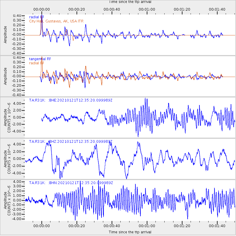
R31K City Hall, Gustavus, AK, USA - Earthquake Result Viewer
*The percent match for this event was below the threshold and hence no stack was calculated.
| Earthquake location: |
Philippine Islands Region |
| Earthquake latitude/longitude: |
5.0/127.5 |
| Earthquake time(UTC): |
2021/01/21 (021) 12:23:05 GMT |
| Earthquake Depth: |
96 km |
| Earthquake Magnitude: |
7.0 mww |
| Earthquake Catalog/Contributor: |
NEIC PDE/us |
|
| Network: |
TA USArray Transportable Network (new EarthScope stations) |
| Station: |
R31K City Hall, Gustavus, AK, USA |
| Lat/Lon: |
58.41 N/135.74 W |
| Elevation: |
15 m |
|
| Distance: |
89.3 deg |
| Az: |
31.516 deg |
| Baz: |
278.343 deg |
| Ray Param: |
$rayparam |
*The percent match for this event was below the threshold and hence was not used in the summary stack. |
|
| Radial Match: |
69.084564 % |
| Radial Bump: |
400 |
| Transverse Match: |
46.64122 % |
| Transverse Bump: |
400 |
| SOD ConfigId: |
23341671 |
| Insert Time: |
2021-02-04 13:38:42.104 +0000 |
| GWidth: |
2.5 |
| Max Bumps: |
400 |
| Tol: |
0.001 |
|
Signal To Noise
| Channel | StoN | STA | LTA |
| TA:R31K: :BHZ:20210121T12:35:20.099989Z | 5.547705 | 3.0494164E-6 | 5.4967165E-7 |
| TA:R31K: :BHN:20210121T12:35:20.099989Z | 0.92689455 | 5.6844556E-7 | 6.1327967E-7 |
| TA:R31K: :BHE:20210121T12:35:20.099989Z | 2.3872736 | 1.3880849E-6 | 5.8145196E-7 |
| Arrivals |
| Ps | |
| PpPs | |
| PsPs/PpSs | |


