You are here: Home > Network List > TA - USArray Transportable Network (new EarthScope stations) Stations List
> Station T35M Bob Quinn, BC, CAN > Earthquake Result Viewer
T35M Bob Quinn, BC, CAN - Earthquake Result Viewer
| Earthquake location: |
Philippine Islands Region |
| Earthquake latitude/longitude: |
5.0/127.5 |
| Earthquake time(UTC): |
2021/01/21 (021) 12:23:05 GMT |
| Earthquake Depth: |
96 km |
| Earthquake Magnitude: |
7.0 mww |
| Earthquake Catalog/Contributor: |
NEIC PDE/us |
|
| Network: |
TA USArray Transportable Network (new EarthScope stations) |
| Station: |
T35M Bob Quinn, BC, CAN |
| Lat/Lon: |
56.98 N/130.25 W |
| Elevation: |
609 m |
|
| Distance: |
92.5 deg |
| Az: |
32.382 deg |
| Baz: |
282.963 deg |
| Ray Param: |
0.04140799 |
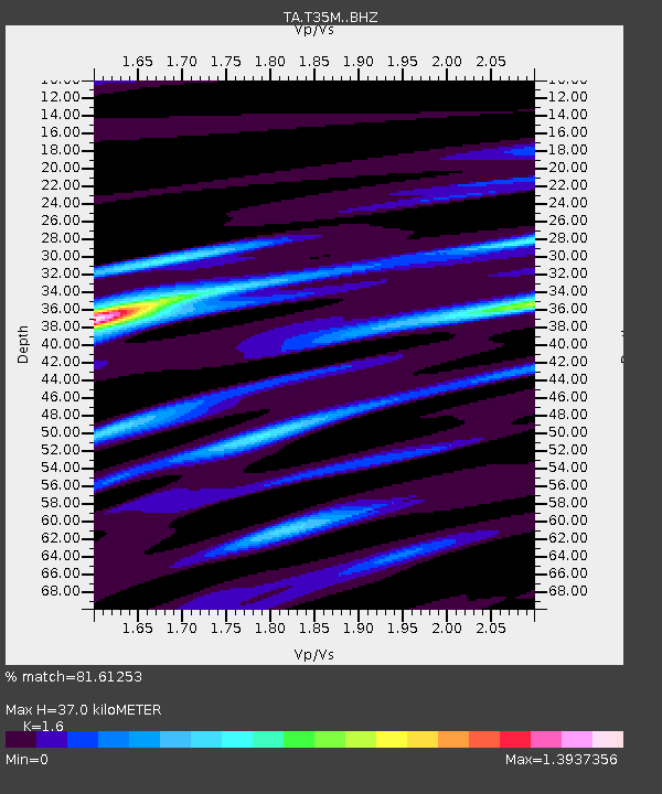
| Estimated Moho Depth: |
37.0 km |
| Estimated Crust Vp/Vs: |
1.60 |
| Assumed Crust Vp: |
6.597 km/s |
| Estimated Crust Vs: |
4.123 km/s |
| Estimated Crust Poisson's Ratio: |
0.18 |
|
| Radial Match: |
81.61253 % |
| Radial Bump: |
400 |
| Transverse Match: |
55.02347 % |
| Transverse Bump: |
400 |
| SOD ConfigId: |
23341671 |
| Insert Time: |
2021-02-04 13:38:47.611 +0000 |
| GWidth: |
2.5 |
| Max Bumps: |
400 |
| Tol: |
0.001 |
|
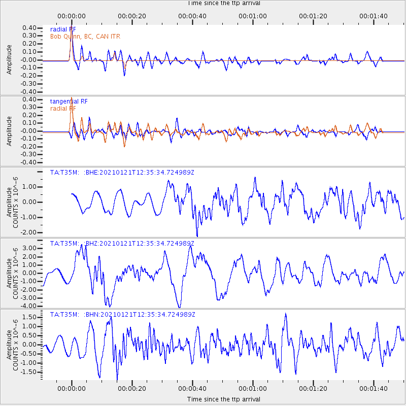
Signal To Noise
| Channel | StoN | STA | LTA |
| TA:T35M: :BHZ:20210121T12:35:34.724989Z | 3.1366646 | 2.26312E-6 | 7.215052E-7 |
| TA:T35M: :BHN:20210121T12:35:34.724989Z | 1.2926198 | 4.6443992E-7 | 3.5930125E-7 |
| TA:T35M: :BHE:20210121T12:35:34.724989Z | 1.7226557 | 8.6285525E-7 | 5.008867E-7 |
| Arrivals |
| Ps | 3.4 SECOND |
| PpPs | 14 SECOND |
| PsPs/PpSs | 18 SECOND |


