You are here: Home > Network List > GE - GEOFON Stations List
> Station KBS IRIS/GEOFON/AWI Station Ny Alesund, Spitsbergen > Earthquake Result Viewer
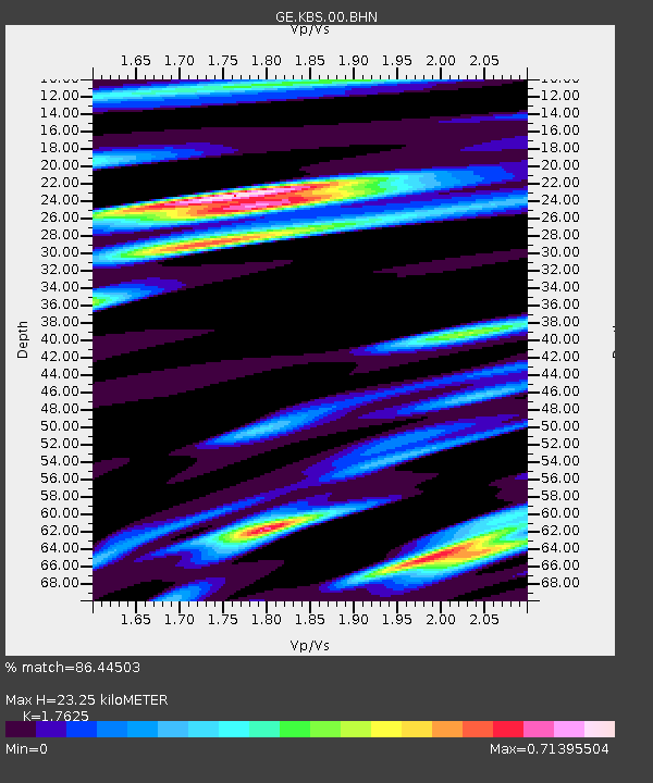
KBS IRIS/GEOFON/AWI Station Ny Alesund, Spitsbergen - Earthquake Result Viewer
| Earthquake location: |
Lake Tanganyika Region |
| Earthquake latitude/longitude: |
-8.0/30.7 |
| Earthquake time(UTC): |
2000/10/02 (276) 02:25:31 GMT |
| Earthquake Depth: |
34 km |
| Earthquake Magnitude: |
6.1 MB, 6.7 MS, 6.5 MW, 6.2 ME |
| Earthquake Catalog/Contributor: |
WHDF/NEIC |
|
| Network: |
GE GEOFON |
| Station: |
KBS IRIS/GEOFON/AWI Station Ny Alesund, Spitsbergen |
| Lat/Lon: |
78.93 N/11.94 E |
| Elevation: |
77 m |
|
| Distance: |
87.4 deg |
| Az: |
356.43 deg |
| Baz: |
161.398 deg |
| Ray Param: |
0.043336727 |
| Estimated Moho Depth: |
23.25 km |
| Estimated Crust Vp/Vs: |
1.76 |
| Assumed Crust Vp: |
6.287 km/s |
| Estimated Crust Vs: |
3.567 km/s |
| Estimated Crust Poisson's Ratio: |
0.26 |
|
| Radial Match: |
86.44503 % |
| Radial Bump: |
400 |
| Transverse Match: |
83.25829 % |
| Transverse Bump: |
400 |
| SOD ConfigId: |
20082 |
| Insert Time: |
2010-03-09 05:01:49.675 +0000 |
| GWidth: |
2.5 |
| Max Bumps: |
400 |
| Tol: |
0.001 |
|

Signal To Noise
| Channel | StoN | STA | LTA |
| GE:KBS:00:BHN:20001002T02:37:43.648013Z | 1.7166493 | 3.1050317E-7 | 1.8087745E-7 |
| GE:KBS:00:BHE:20001002T02:37:43.648013Z | 1.3421805 | 1.7996729E-7 | 1.3408577E-7 |
| GE:KBS:00:BHZ:20001002T02:37:43.648013Z | 5.197474 | 8.272898E-7 | 1.591715E-7 |
| Arrivals |
| Ps | 2.9 SECOND |
| PpPs | 10.0 SECOND |
| PsPs/PpSs | 13 SECOND |


