You are here: Home > Network List > CI - Caltech Regional Seismic Network Stations List
> Station DAN Danby, California, USA > Earthquake Result Viewer
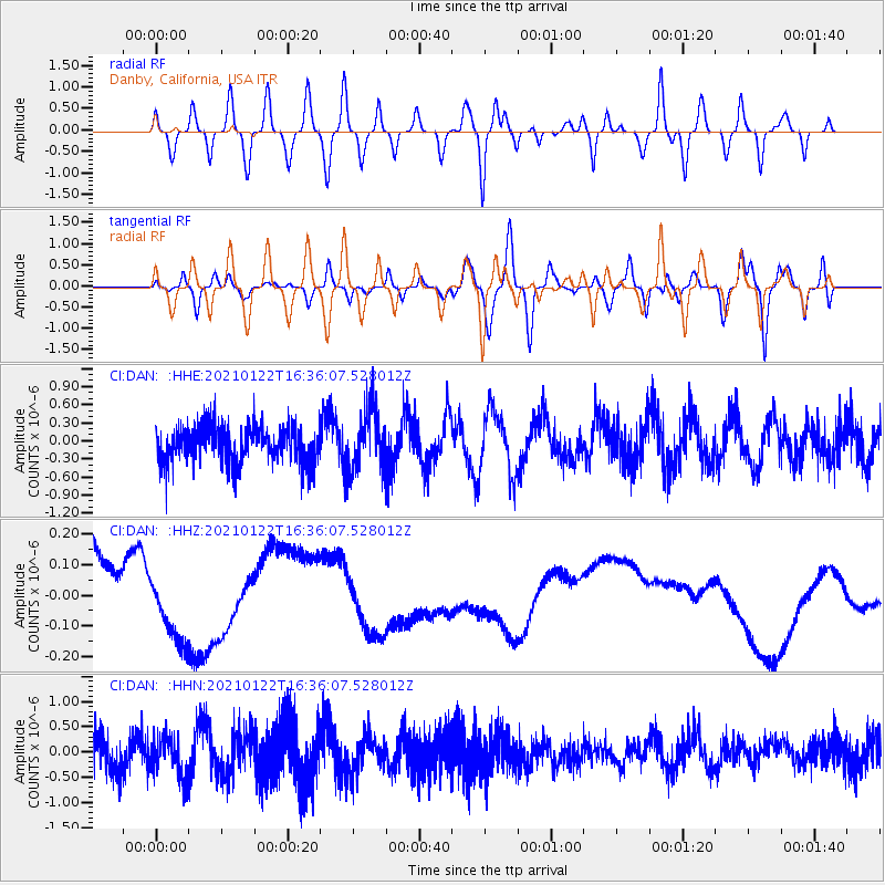
DAN Danby, California, USA - Earthquake Result Viewer
*The percent match for this event was below the threshold and hence no stack was calculated.
| Earthquake location: |
South Of Kermadec Islands |
| Earthquake latitude/longitude: |
-33.2/-179.5 |
| Earthquake time(UTC): |
2021/01/22 (022) 16:23:42 GMT |
| Earthquake Depth: |
46 km |
| Earthquake Magnitude: |
5.6 Mww |
| Earthquake Catalog/Contributor: |
NEIC PDE/us |
|
| Network: |
CI Caltech Regional Seismic Network |
| Station: |
DAN Danby, California, USA |
| Lat/Lon: |
34.64 N/115.38 W |
| Elevation: |
398 m |
|
| Distance: |
90.3 deg |
| Az: |
47.882 deg |
| Baz: |
228.996 deg |
| Ray Param: |
$rayparam |
*The percent match for this event was below the threshold and hence was not used in the summary stack. |
|
| Radial Match: |
53.084194 % |
| Radial Bump: |
400 |
| Transverse Match: |
50.482487 % |
| Transverse Bump: |
400 |
| SOD ConfigId: |
23341671 |
| Insert Time: |
2021-02-05 17:30:02.170 +0000 |
| GWidth: |
2.5 |
| Max Bumps: |
400 |
| Tol: |
0.001 |
|
Signal To Noise
| Channel | StoN | STA | LTA |
| CI:DAN: :HHZ:20210122T16:36:07.528012Z | 0.41976532 | 8.308401E-8 | 1.9792968E-7 |
| CI:DAN: :HHN:20210122T16:36:07.528012Z | 1.0000517 | 3.9027532E-7 | 3.9025514E-7 |
| CI:DAN: :HHE:20210122T16:36:07.528012Z | 1.5884467 | 4.975938E-7 | 3.1325808E-7 |
| Arrivals |
| Ps | |
| PpPs | |
| PsPs/PpSs | |


