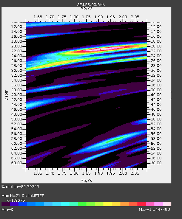
KBS IRIS/GEOFON/AWI Station Ny Alesund, Spitsbergen - Earthquake Result Viewer

Earthquake location: Southeast Of Honshu, Japan
Earthquake latitude/longitude: 33.9/139.4
Earthquake time(UTC): 2000/07/30 (212) 12:25:45 GMT
Earthquake Depth: 10 km
Earthquake Magnitude: 6.0 MB, 6.5 MS, 6.5 MW, 6.5 MW
Earthquake Catalog/Contributor: WHDF/NEIC
Network: GE GEOFON
Station: KBS IRIS/GEOFON/AWI Station Ny Alesund, Spitsbergen
Lat/Lon: 78.93 N/11.94 E
Elevation: 77 m
Distance: 63.5 deg
Az: 350.119 deg
Baz: 47.586 deg
Ray Param: 0.059568614
Estimated Moho Depth: 21.0 km
Estimated Crust Vp/Vs: 1.91
Assumed Crust Vp: 6.287 km/s
Estimated Crust Vs: 3.296 km/s
Estimated Crust Poisson's Ratio: 0.31
Radial Match: 82.79343 %
Radial Bump: 400
Transverse Match: 70.56292 %
Transverse Bump: 400
SOD ConfigId: 20082
Insert Time: 2010-03-09 05:01:55.873 +0000
GWidth: 2.5
Max Bumps: 400
Tol: 0.001

Signal To Noise

ChannelStoNSTALTA
GE:KBS:00:BHN:20000730T12:35:44.348015Z1.01581941.6049277E-71.5799341E-7
GE:KBS:00:BHE:20000730T12:35:44.348015Z1.30503382.2980731E-71.76093E-7
GE:KBS:00:BHZ:20000730T12:35:44.348015Z1.01681572.4193267E-72.3793169E-7
Arrivals
Ps3.2 SECOND
PpPs9.3 SECOND
PsPs/PpSs12 SECOND