You are here: Home > Network List > AV - Alaska Volcano Observatory Stations List
> Station MAPS Pakushin Southeast, Makushin Volcano, Alaska > Earthquake Result Viewer
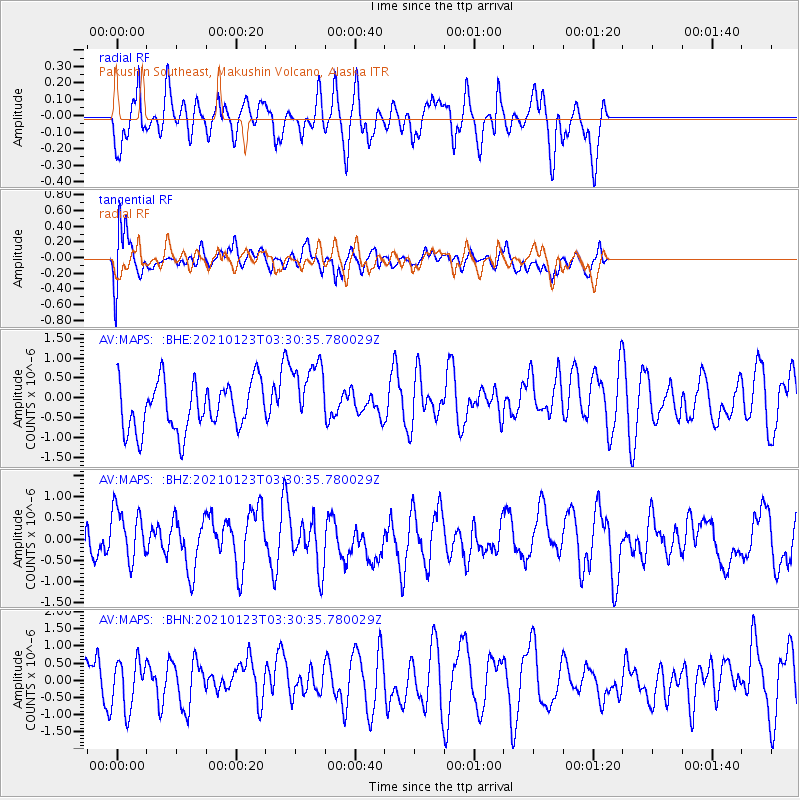
MAPS Pakushin Southeast, Makushin Volcano, Alaska - Earthquake Result Viewer
*The percent match for this event was below the threshold and hence no stack was calculated.
| Earthquake location: |
Eastern New Guinea Reg., P.N.G. |
| Earthquake latitude/longitude: |
-6.3/147.6 |
| Earthquake time(UTC): |
2021/01/23 (023) 03:19:51 GMT |
| Earthquake Depth: |
29 km |
| Earthquake Magnitude: |
5.7 mww |
| Earthquake Catalog/Contributor: |
NEIC PDE/us |
|
| Network: |
AV Alaska Volcano Observatory |
| Station: |
MAPS Pakushin Southeast, Makushin Volcano, Alaska |
| Lat/Lon: |
53.81 N/166.94 W |
| Elevation: |
333 m |
|
| Distance: |
71.0 deg |
| Az: |
26.552 deg |
| Baz: |
228.518 deg |
| Ray Param: |
$rayparam |
*The percent match for this event was below the threshold and hence was not used in the summary stack. |
|
| Radial Match: |
57.26681 % |
| Radial Bump: |
400 |
| Transverse Match: |
56.761364 % |
| Transverse Bump: |
400 |
| SOD ConfigId: |
23341671 |
| Insert Time: |
2021-02-06 04:23:53.945 +0000 |
| GWidth: |
2.5 |
| Max Bumps: |
400 |
| Tol: |
0.001 |
|
Signal To Noise
| Channel | StoN | STA | LTA |
| AV:MAPS: :BHZ:20210123T03:30:35.780029Z | 1.4276403 | 6.403351E-7 | 4.485269E-7 |
| AV:MAPS: :BHN:20210123T03:30:35.780029Z | 0.8451669 | 7.1091085E-7 | 8.4114845E-7 |
| AV:MAPS: :BHE:20210123T03:30:35.780029Z | 1.4615427 | 8.942191E-7 | 6.118323E-7 |
| Arrivals |
| Ps | |
| PpPs | |
| PsPs/PpSs | |


