You are here: Home > Network List > PS - Pacific21 Stations List
> Station PSI Parapat, Indonesia > Earthquake Result Viewer
PSI Parapat, Indonesia - Earthquake Result Viewer
| Earthquake location: |
Eastern New Guinea Reg., P.N.G. |
| Earthquake latitude/longitude: |
-6.3/147.6 |
| Earthquake time(UTC): |
2021/01/23 (023) 03:19:51 GMT |
| Earthquake Depth: |
29 km |
| Earthquake Magnitude: |
5.7 mww |
| Earthquake Catalog/Contributor: |
NEIC PDE/us |
|
| Network: |
PS Pacific21 |
| Station: |
PSI Parapat, Indonesia |
| Lat/Lon: |
2.69 N/98.92 E |
| Elevation: |
987 m |
|
| Distance: |
49.4 deg |
| Az: |
278.993 deg |
| Baz: |
100.635 deg |
| Ray Param: |
0.06867684 |
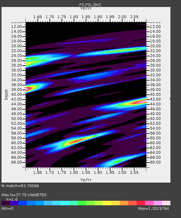
| Estimated Moho Depth: |
37.75 km |
| Estimated Crust Vp/Vs: |
1.60 |
| Assumed Crust Vp: |
6.468 km/s |
| Estimated Crust Vs: |
4.042 km/s |
| Estimated Crust Poisson's Ratio: |
0.18 |
|
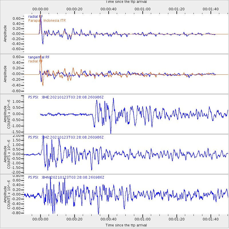
| Radial Match: |
93.78066 % |
| Radial Bump: |
400 |
| Transverse Match: |
71.22204 % |
| Transverse Bump: |
400 |
| SOD ConfigId: |
23341671 |
| Insert Time: |
2021-02-06 04:29:28.564 +0000 |
| GWidth: |
2.5 |
| Max Bumps: |
400 |
| Tol: |
0.001 |
|
Signal To Noise
| Channel | StoN | STA | LTA |
| PS:PSI: :BHZ:20210123T03:28:08.260986Z | 21.955038 | 9.616876E-7 | 4.3802597E-8 |
| PS:PSI: :BHN:20210123T03:28:08.260986Z | 1.8736026 | 2.2285074E-7 | 1.18942374E-7 |
| PS:PSI: :BHE:20210123T03:28:08.260986Z | 13.386703 | 5.915213E-7 | 4.418723E-8 |
| Arrivals |
| Ps | 3.7 SECOND |
| PpPs | 14 SECOND |
| PsPs/PpSs | 18 SECOND |


