You are here: Home > Network List > GE - GEOFON Stations List
> Station KBS IRIS/GEOFON/AWI Station Ny Alesund, Spitsbergen > Earthquake Result Viewer
KBS IRIS/GEOFON/AWI Station Ny Alesund, Spitsbergen - Earthquake Result Viewer
| Earthquake location: |
Mariana Islands |
| Earthquake latitude/longitude: |
18.8/147.0 |
| Earthquake time(UTC): |
2001/06/15 (166) 06:17:45 GMT |
| Earthquake Depth: |
33 km |
| Earthquake Magnitude: |
5.4 MB, 5.9 MS, 6.0 MW, 6.0 MW |
| Earthquake Catalog/Contributor: |
WHDF/NEIC |
|
| Network: |
GE GEOFON |
| Station: |
KBS IRIS/GEOFON/AWI Station Ny Alesund, Spitsbergen |
| Lat/Lon: |
78.93 N/11.94 E |
| Elevation: |
77 m |
|
| Distance: |
79.3 deg |
| Az: |
352.009 deg |
| Baz: |
42.923 deg |
| Ray Param: |
0.04899324 |
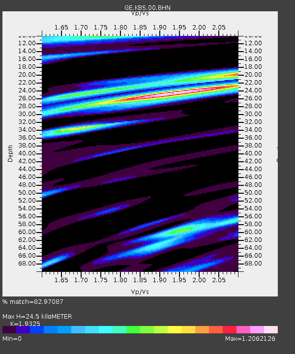
| Estimated Moho Depth: |
24.5 km |
| Estimated Crust Vp/Vs: |
1.93 |
| Assumed Crust Vp: |
6.287 km/s |
| Estimated Crust Vs: |
3.254 km/s |
| Estimated Crust Poisson's Ratio: |
0.32 |
|
| Radial Match: |
82.97087 % |
| Radial Bump: |
400 |
| Transverse Match: |
55.761547 % |
| Transverse Bump: |
400 |
| SOD ConfigId: |
20082 |
| Insert Time: |
2010-03-09 05:02:34.355 +0000 |
| GWidth: |
2.5 |
| Max Bumps: |
400 |
| Tol: |
0.001 |
|

Signal To Noise
| Channel | StoN | STA | LTA |
| GE:KBS:00:BHN:20010615T06:29:16.611006Z | 0.961127 | 8.658834E-8 | 9.0090424E-8 |
| GE:KBS:00:BHE:20010615T06:29:16.611006Z | 0.78718615 | 6.299812E-8 | 8.002951E-8 |
| GE:KBS:00:BHZ:20010615T06:29:16.611006Z | 2.8421714 | 3.1462716E-7 | 1.10699574E-7 |
| Arrivals |
| Ps | 3.7 SECOND |
| PpPs | 11 SECOND |
| PsPs/PpSs | 15 SECOND |


