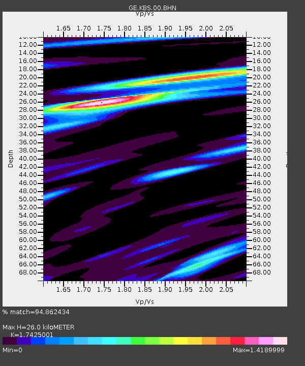
KBS IRIS/GEOFON/AWI Station Ny Alesund, Spitsbergen - Earthquake Result Viewer

Earthquake location: Andreanof Islands, Aleutian Is.
Earthquake latitude/longitude: 51.2/-179.8
Earthquake time(UTC): 2001/06/14 (165) 19:48:47 GMT
Earthquake Depth: 18 km
Earthquake Magnitude: 6.0 MB, 6.3 MS, 6.5 MW, 6.1 ML
Earthquake Catalog/Contributor: WHDF/NEIC
Network: GE GEOFON
Station: KBS IRIS/GEOFON/AWI Station Ny Alesund, Spitsbergen
Lat/Lon: 78.93 N/11.94 E
Elevation: 77 m
Distance: 50.0 deg
Az: 357.048 deg
Baz: 9.655 deg
Ray Param: 0.068333395
Estimated Moho Depth: 26.0 km
Estimated Crust Vp/Vs: 1.74
Assumed Crust Vp: 6.287 km/s
Estimated Crust Vs: 3.608 km/s
Estimated Crust Poisson's Ratio: 0.25
Radial Match: 94.862434 %
Radial Bump: 378
Transverse Match: 87.79448 %
Transverse Bump: 400
SOD ConfigId: 20082
Insert Time: 2010-03-09 05:02:35.581 +0000
GWidth: 2.5
Max Bumps: 400
Tol: 0.001

Signal To Noise

ChannelStoNSTALTA
GE:KBS:00:BHN:20010614T19:57:09.959009Z12.8579347.771568E-76.0441806E-8
GE:KBS:00:BHE:20010614T19:57:09.959009Z2.50188161.9325115E-77.7242326E-8
GE:KBS:00:BHZ:20010614T19:57:09.959009Z14.3797321.3991734E-69.730177E-8
Arrivals
Ps3.2 SECOND
PpPs11 SECOND
PsPs/PpSs14 SECOND