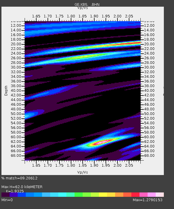
KBS IRIS/GEOFON/AWI Station Ny Alesund, Spitsbergen - Earthquake Result Viewer

Earthquake location: Minahassa Peninsula, Sulawesi
Earthquake latitude/longitude: 1.2/122.5
Earthquake time(UTC): 1997/11/25 (329) 12:14:33 GMT
Earthquake Depth: 24 km
Earthquake Magnitude: 6.1 MB, 6.8 MS, 7.1 UNKNOWN, 6.7 ME
Earthquake Catalog/Contributor: WHDF/NEIC
Network: GE GEOFON
Station: KBS IRIS/GEOFON/AWI Station Ny Alesund, Spitsbergen
Lat/Lon: 78.93 N/11.94 E
Elevation: 77 m
Distance: 92.7 deg
Az: 349.562 deg
Baz: 69.539 deg
Ray Param: 0.041402802
Estimated Moho Depth: 62.0 km
Estimated Crust Vp/Vs: 1.93
Assumed Crust Vp: 6.287 km/s
Estimated Crust Vs: 3.254 km/s
Estimated Crust Poisson's Ratio: 0.32
Radial Match: 89.28612 %
Radial Bump: 400
Transverse Match: 78.01483 %
Transverse Bump: 400
SOD ConfigId: 4480
Insert Time: 2010-03-09 05:02:48.068 +0000
GWidth: 2.5
Max Bumps: 400
Tol: 0.001

Signal To Noise

ChannelStoNSTALTA
GE:KBS: :BHN:19971125T12:27:11.915002Z2.31986454.6379333E-71.999226E-7
GE:KBS: :BHE:19971125T12:27:11.915002Z0.539025379.796162E-81.8173843E-7
GE:KBS: :BHZ:19971125T12:27:11.915002Z1.24882852.092598E-71.6756486E-7
Arrivals
Ps9.4 SECOND
PpPs28 SECOND
PsPs/PpSs38 SECOND