You are here: Home > Network List > GE - GEOFON Stations List
> Station KBS IRIS/GEOFON/AWI Station Ny Alesund, Spitsbergen > Earthquake Result Viewer
KBS IRIS/GEOFON/AWI Station Ny Alesund, Spitsbergen - Earthquake Result Viewer
| Earthquake location: |
Arabian Sea |
| Earthquake latitude/longitude: |
14.7/55.8 |
| Earthquake time(UTC): |
2002/08/13 (225) 08:37:22 GMT |
| Earthquake Depth: |
10 km |
| Earthquake Magnitude: |
5.8 MB, 5.5 MS, 5.8 MW, 5.6 MW |
| Earthquake Catalog/Contributor: |
WHDF/NEIC |
|
| Network: |
GE GEOFON |
| Station: |
KBS IRIS/GEOFON/AWI Station Ny Alesund, Spitsbergen |
| Lat/Lon: |
78.93 N/11.94 E |
| Elevation: |
77 m |
|
| Distance: |
67.5 deg |
| Az: |
351.655 deg |
| Baz: |
133.421 deg |
| Ray Param: |
0.056927633 |
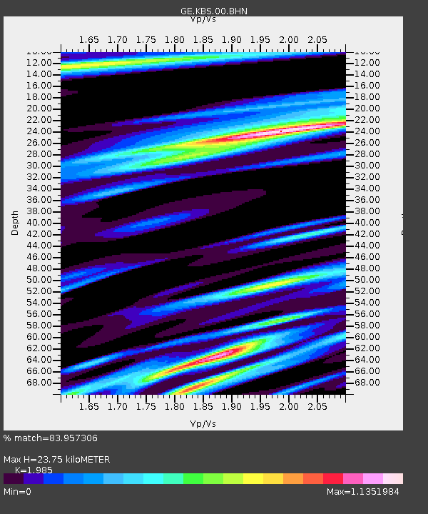
| Estimated Moho Depth: |
23.75 km |
| Estimated Crust Vp/Vs: |
1.99 |
| Assumed Crust Vp: |
6.287 km/s |
| Estimated Crust Vs: |
3.168 km/s |
| Estimated Crust Poisson's Ratio: |
0.33 |
|
| Radial Match: |
83.957306 % |
| Radial Bump: |
347 |
| Transverse Match: |
82.66496 % |
| Transverse Bump: |
400 |
| SOD ConfigId: |
20082 |
| Insert Time: |
2010-03-09 05:02:49.511 +0000 |
| GWidth: |
2.5 |
| Max Bumps: |
400 |
| Tol: |
0.001 |
|

Signal To Noise
| Channel | StoN | STA | LTA |
| GE:KBS:00:BHN:20020813T08:47:47.561016Z | 1.3205734 | 6.454562E-8 | 4.887696E-8 |
| GE:KBS:00:BHE:20020813T08:47:47.561016Z | 1.526647 | 6.650765E-8 | 4.3564526E-8 |
| GE:KBS:00:BHZ:20020813T08:47:47.561016Z | 2.6039224 | 1.8744903E-7 | 7.198718E-8 |
| Arrivals |
| Ps | 3.8 SECOND |
| PpPs | 11 SECOND |
| PsPs/PpSs | 15 SECOND |


