You are here: Home > Network List > CI - Caltech Regional Seismic Network Stations List
> Station CWC Cottonwood Creek, Lone Pine, CA, USA > Earthquake Result Viewer
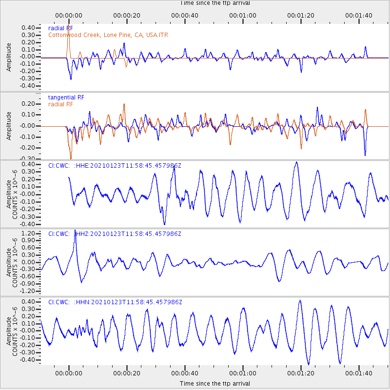
CWC Cottonwood Creek, Lone Pine, CA, USA - Earthquake Result Viewer
*The percent match for this event was below the threshold and hence no stack was calculated.
| Earthquake location: |
South Of Fiji Islands |
| Earthquake latitude/longitude: |
-24.3/-179.5 |
| Earthquake time(UTC): |
2021/01/23 (023) 11:47:33 GMT |
| Earthquake Depth: |
425 km |
| Earthquake Magnitude: |
5.5 mww |
| Earthquake Catalog/Contributor: |
NEIC PDE/us |
|
| Network: |
CI Caltech Regional Seismic Network |
| Station: |
CWC Cottonwood Creek, Lone Pine, CA, USA |
| Lat/Lon: |
36.44 N/118.08 W |
| Elevation: |
1595 m |
|
| Distance: |
83.7 deg |
| Az: |
45.434 deg |
| Baz: |
233.703 deg |
| Ray Param: |
$rayparam |
*The percent match for this event was below the threshold and hence was not used in the summary stack. |
|
| Radial Match: |
55.05457 % |
| Radial Bump: |
400 |
| Transverse Match: |
67.84929 % |
| Transverse Bump: |
400 |
| SOD ConfigId: |
23341671 |
| Insert Time: |
2021-02-06 12:54:01.633 +0000 |
| GWidth: |
2.5 |
| Max Bumps: |
400 |
| Tol: |
0.001 |
|
Signal To Noise
| Channel | StoN | STA | LTA |
| CI:CWC: :HHZ:20210123T11:58:45.457986Z | 2.319582 | 5.810508E-7 | 2.5049806E-7 |
| CI:CWC: :HHN:20210123T11:58:45.457986Z | 0.19368398 | 3.958028E-8 | 2.0435493E-7 |
| CI:CWC: :HHE:20210123T11:58:45.457986Z | 2.7975023 | 2.1606189E-7 | 7.723386E-8 |
| Arrivals |
| Ps | |
| PpPs | |
| PsPs/PpSs | |


