You are here: Home > Network List > US - United States National Seismic Network Stations List
> Station AMTX Amarillo, Texas, USA > Earthquake Result Viewer
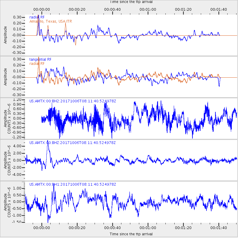
AMTX Amarillo, Texas, USA - Earthquake Result Viewer
*The percent match for this event was below the threshold and hence no stack was calculated.
| Earthquake location: |
Off East Coast Of Honshu, Japan |
| Earthquake latitude/longitude: |
37.5/144.0 |
| Earthquake time(UTC): |
2017/10/06 (279) 07:59:33 GMT |
| Earthquake Depth: |
10 km |
| Earthquake Magnitude: |
6.0 Mww |
| Earthquake Catalog/Contributor: |
NEIC PDE/us |
|
| Network: |
US United States National Seismic Network |
| Station: |
AMTX Amarillo, Texas, USA |
| Lat/Lon: |
34.53 N/101.41 W |
| Elevation: |
1010 m |
|
| Distance: |
86.1 deg |
| Az: |
48.78 deg |
| Baz: |
313.552 deg |
| Ray Param: |
$rayparam |
*The percent match for this event was below the threshold and hence was not used in the summary stack. |
|
| Radial Match: |
76.77311 % |
| Radial Bump: |
400 |
| Transverse Match: |
41.775436 % |
| Transverse Bump: |
400 |
| SOD ConfigId: |
2364251 |
| Insert Time: |
2017-10-20 08:07:52.737 +0000 |
| GWidth: |
2.5 |
| Max Bumps: |
400 |
| Tol: |
0.001 |
|
Signal To Noise
| Channel | StoN | STA | LTA |
| US:AMTX:00:BHZ:20171006T08:11:40.524978Z | 8.573527 | 2.391336E-6 | 2.7892094E-7 |
| US:AMTX:00:BH1:20171006T08:11:40.524978Z | 2.555607 | 7.1181677E-7 | 2.785314E-7 |
| US:AMTX:00:BH2:20171006T08:11:40.524978Z | 1.6335052 | 5.711135E-7 | 3.4962451E-7 |
| Arrivals |
| Ps | |
| PpPs | |
| PsPs/PpSs | |


