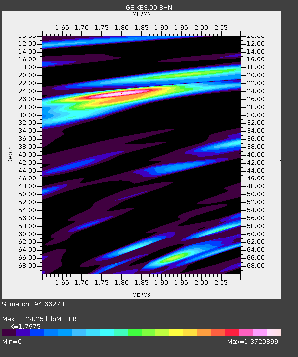
KBS IRIS/GEOFON/AWI Station Ny Alesund, Spitsbergen - Earthquake Result Viewer

Earthquake location: Rat Islands, Aleutian Islands
Earthquake latitude/longitude: 51.6/176.9
Earthquake time(UTC): 2003/06/15 (166) 19:24:33 GMT
Earthquake Depth: 20 km
Earthquake Magnitude: 6.0 MB, 6.4 MS, 6.5 MW, 6.5 MW
Earthquake Catalog/Contributor: WHDF/NEIC
Network: GE GEOFON
Station: KBS IRIS/GEOFON/AWI Station Ny Alesund, Spitsbergen
Lat/Lon: 78.93 N/11.94 E
Elevation: 77 m
Distance: 49.5 deg
Az: 356.221 deg
Baz: 12.29 deg
Ray Param: 0.06865341
Estimated Moho Depth: 24.25 km
Estimated Crust Vp/Vs: 1.80
Assumed Crust Vp: 6.287 km/s
Estimated Crust Vs: 3.498 km/s
Estimated Crust Poisson's Ratio: 0.28
Radial Match: 94.66278 %
Radial Bump: 400
Transverse Match: 83.91933 %
Transverse Bump: 400
SOD ConfigId: 4714
Insert Time: 2010-03-09 05:03:08.624 +0000
GWidth: 2.5
Max Bumps: 400
Tol: 0.001

Signal To Noise

ChannelStoNSTALTA
GE:KBS:00:BHN:20030615T19:32:51.096991Z11.7688456.8324545E-75.8055434E-8
GE:KBS:00:BHE:20030615T19:32:51.096991Z3.54498892.3054777E-76.503484E-8
GE:KBS:00:BHZ:20030615T19:32:51.096991Z13.8009081.2235233E-68.865527E-8
Arrivals
Ps3.3 SECOND
PpPs10 SECOND
PsPs/PpSs13 SECOND