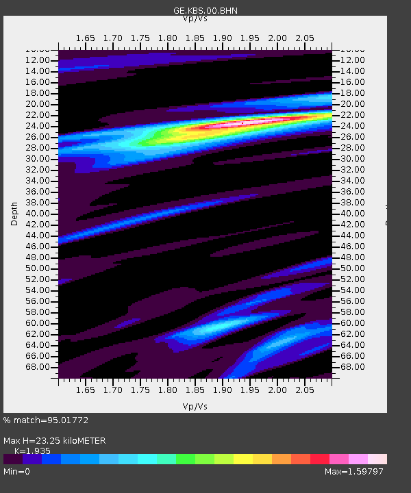
KBS IRIS/GEOFON/AWI Station Ny Alesund, Spitsbergen - Earthquake Result Viewer

Earthquake location: Near S. Coast Of Western Honshu
Earthquake latitude/longitude: 33.1/136.6
Earthquake time(UTC): 2004/09/05 (249) 10:07:07 GMT
Earthquake Depth: 14 km
Earthquake Magnitude: 6.7 MB, 7.0 MS, 7.2 MW, 7.0 MW
Earthquake Catalog/Contributor: WHDF/NEIC
Network: GE GEOFON
Station: KBS IRIS/GEOFON/AWI Station Ny Alesund, Spitsbergen
Lat/Lon: 78.93 N/11.94 E
Elevation: 77 m
Distance: 63.9 deg
Az: 349.799 deg
Baz: 50.28 deg
Ray Param: 0.059289027
Estimated Moho Depth: 23.25 km
Estimated Crust Vp/Vs: 1.93
Assumed Crust Vp: 6.287 km/s
Estimated Crust Vs: 3.249 km/s
Estimated Crust Poisson's Ratio: 0.32
Radial Match: 95.01772 %
Radial Bump: 400
Transverse Match: 87.46785 %
Transverse Bump: 400
SOD ConfigId: 2459
Insert Time: 2010-03-09 05:03:16.796 +0000
GWidth: 2.5
Max Bumps: 400
Tol: 0.001

Signal To Noise

ChannelStoNSTALTA
GE:KBS:00:BHN:20040905T10:17:08.697014Z9.9355482.0241816E-62.0373126E-7
GE:KBS:00:BHE:20040905T10:17:08.697014Z15.5631753.0110282E-61.9347132E-7
GE:KBS:00:BHZ:20040905T10:17:08.697014Z33.419317.447438E-62.2284831E-7
Arrivals
Ps3.6 SECOND
PpPs10 SECOND
PsPs/PpSs14 SECOND