You are here: Home > Network List > WY - Yellowstone Wyoming Seismic Network Stations List
> Station YEE East Entrance, YNP, WY, USA > Earthquake Result Viewer
YEE East Entrance, YNP, WY, USA - Earthquake Result Viewer
| Earthquake location: |
South Of Fiji Islands |
| Earthquake latitude/longitude: |
-24.3/-179.5 |
| Earthquake time(UTC): |
2021/01/23 (023) 11:47:33 GMT |
| Earthquake Depth: |
425 km |
| Earthquake Magnitude: |
5.5 mww |
| Earthquake Catalog/Contributor: |
NEIC PDE/us |
|
| Network: |
WY Yellowstone Wyoming Seismic Network |
| Station: |
YEE East Entrance, YNP, WY, USA |
| Lat/Lon: |
44.49 N/109.90 W |
| Elevation: |
2270 m |
|
| Distance: |
93.4 deg |
| Az: |
42.228 deg |
| Baz: |
238.929 deg |
| Ray Param: |
0.040951606 |
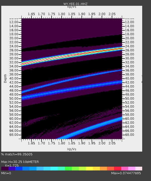
| Estimated Moho Depth: |
30.25 km |
| Estimated Crust Vp/Vs: |
1.73 |
| Assumed Crust Vp: |
6.242 km/s |
| Estimated Crust Vs: |
3.619 km/s |
| Estimated Crust Poisson's Ratio: |
0.25 |
|
| Radial Match: |
99.35005 % |
| Radial Bump: |
33 |
| Transverse Match: |
85.272385 % |
| Transverse Bump: |
400 |
| SOD ConfigId: |
23341671 |
| Insert Time: |
2021-02-06 13:02:45.578 +0000 |
| GWidth: |
2.5 |
| Max Bumps: |
400 |
| Tol: |
0.001 |
|

Signal To Noise
| Channel | StoN | STA | LTA |
| WY:YEE:01:HHZ:20210123T11:59:30.74003Z | 9.024358 | 1.6865123E-7 | 1.8688446E-8 |
| WY:YEE:01:HHN:20210123T11:59:30.74003Z | 4.1550097 | 4.5316362E-8 | 1.0906439E-8 |
| WY:YEE:01:HHE:20210123T11:59:30.74003Z | 9.489482 | 1.6233382E-7 | 1.7106709E-8 |
| Arrivals |
| Ps | 3.6 SECOND |
| PpPs | 13 SECOND |
| PsPs/PpSs | 17 SECOND |


