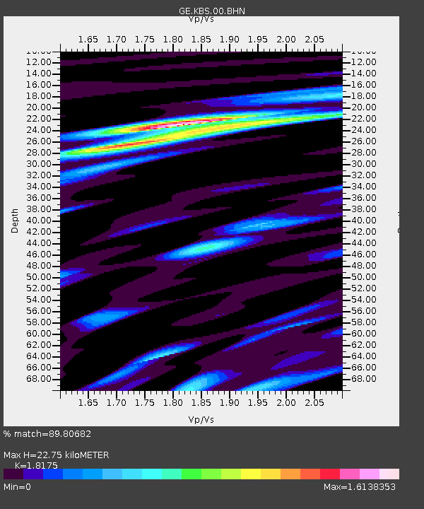
KBS IRIS/GEOFON/AWI Station Ny Alesund, Spitsbergen - Earthquake Result Viewer

Earthquake location: South Of Aleutian Islands
Earthquake latitude/longitude: 51.8/-166.3
Earthquake time(UTC): 2004/08/07 (220) 09:30:16 GMT
Earthquake Depth: 8.0 km
Earthquake Magnitude: 6.3 MB, 5.4 MS, 6.0 MW, 6.0 MW
Earthquake Catalog/Contributor: WHDF/NEIC
Network: GE GEOFON
Station: KBS IRIS/GEOFON/AWI Station Ny Alesund, Spitsbergen
Lat/Lon: 78.93 N/11.94 E
Elevation: 77 m
Distance: 49.6 deg
Az: 0.443 deg
Baz: 358.575 deg
Ray Param: 0.068616845
Estimated Moho Depth: 22.75 km
Estimated Crust Vp/Vs: 1.82
Assumed Crust Vp: 6.287 km/s
Estimated Crust Vs: 3.459 km/s
Estimated Crust Poisson's Ratio: 0.28
Radial Match: 89.80682 %
Radial Bump: 400
Transverse Match: 76.22634 %
Transverse Bump: 400
SOD ConfigId: 2459
Insert Time: 2010-03-09 05:03:19.219 +0000
GWidth: 2.5
Max Bumps: 400
Tol: 0.001

Signal To Noise

ChannelStoNSTALTA
GE:KBS:00:BHN:20040807T09:38:37.41699Z7.78966671.0335389E-61.3268077E-7
GE:KBS:00:BHE:20040807T09:38:37.41699Z2.3022432.8270532E-71.227956E-7
GE:KBS:00:BHZ:20040807T09:38:37.41699Z12.497851.8293736E-61.4637506E-7
Arrivals
Ps3.1 SECOND
PpPs9.7 SECOND
PsPs/PpSs13 SECOND