You are here: Home > Network List > TA - USArray Transportable Network (new EarthScope stations) Stations List
> Station R33M Jennings River, BC, CAN > Earthquake Result Viewer
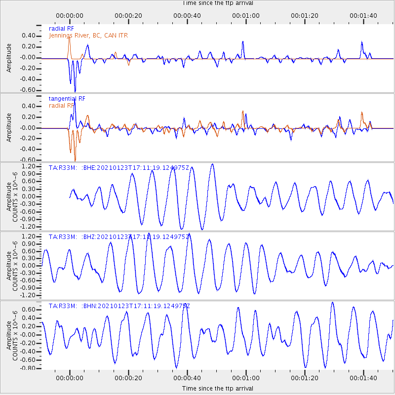
R33M Jennings River, BC, CAN - Earthquake Result Viewer
*The percent match for this event was below the threshold and hence no stack was calculated.
| Earthquake location: |
Eastern New Guinea Reg., P.N.G. |
| Earthquake latitude/longitude: |
-6.3/147.7 |
| Earthquake time(UTC): |
2021/01/23 (023) 16:58:52 GMT |
| Earthquake Depth: |
53 km |
| Earthquake Magnitude: |
5.5 mww |
| Earthquake Catalog/Contributor: |
NEIC PDE/us |
|
| Network: |
TA USArray Transportable Network (new EarthScope stations) |
| Station: |
R33M Jennings River, BC, CAN |
| Lat/Lon: |
59.39 N/130.97 W |
| Elevation: |
1437 m |
|
| Distance: |
90.9 deg |
| Az: |
30.39 deg |
| Baz: |
259.388 deg |
| Ray Param: |
$rayparam |
*The percent match for this event was below the threshold and hence was not used in the summary stack. |
|
| Radial Match: |
56.924847 % |
| Radial Bump: |
326 |
| Transverse Match: |
83.641396 % |
| Transverse Bump: |
400 |
| SOD ConfigId: |
23341671 |
| Insert Time: |
2021-02-06 18:08:02.671 +0000 |
| GWidth: |
2.5 |
| Max Bumps: |
400 |
| Tol: |
0.001 |
|
Signal To Noise
| Channel | StoN | STA | LTA |
| TA:R33M: :BHZ:20210123T17:11:19.124975Z | 1.2339113 | 4.150034E-7 | 3.3633165E-7 |
| TA:R33M: :BHN:20210123T17:11:19.124975Z | 0.5229149 | 1.2633674E-7 | 2.4160096E-7 |
| TA:R33M: :BHE:20210123T17:11:19.124975Z | 1.7893796 | 7.4307866E-7 | 4.1527167E-7 |
| Arrivals |
| Ps | |
| PpPs | |
| PsPs/PpSs | |


