You are here: Home > Network List > AU - Australian Seismological Centre Stations List
> Station CMSA Cobar, New South Wales > Earthquake Result Viewer
CMSA Cobar, New South Wales - Earthquake Result Viewer
| Earthquake location: |
South Shetland Islands |
| Earthquake latitude/longitude: |
-61.8/-55.6 |
| Earthquake time(UTC): |
2021/01/23 (023) 23:36:50 GMT |
| Earthquake Depth: |
7.8 km |
| Earthquake Magnitude: |
7.0 mww |
| Earthquake Catalog/Contributor: |
NEIC PDE/us |
|
| Network: |
AU Australian Seismological Centre |
| Station: |
CMSA Cobar, New South Wales |
| Lat/Lon: |
31.54 S/145.69 E |
| Elevation: |
220 m |
|
| Distance: |
85.4 deg |
| Az: |
198.089 deg |
| Baz: |
170.069 deg |
| Ray Param: |
0.04482169 |
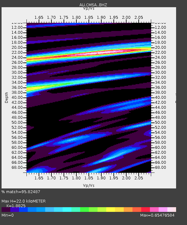
| Estimated Moho Depth: |
22.0 km |
| Estimated Crust Vp/Vs: |
1.88 |
| Assumed Crust Vp: |
6.522 km/s |
| Estimated Crust Vs: |
3.464 km/s |
| Estimated Crust Poisson's Ratio: |
0.30 |
|
| Radial Match: |
95.82487 % |
| Radial Bump: |
294 |
| Transverse Match: |
90.51036 % |
| Transverse Bump: |
400 |
| SOD ConfigId: |
23341671 |
| Insert Time: |
2021-02-07 00:38:04.944 +0000 |
| GWidth: |
2.5 |
| Max Bumps: |
400 |
| Tol: |
0.001 |
|

Signal To Noise
| Channel | StoN | STA | LTA |
| AU:CMSA: :BHZ:20210123T23:48:56.943979Z | 2.3311443 | 8.112264E-7 | 3.4799493E-7 |
| AU:CMSA: :BHN:20210123T23:48:56.943979Z | 1.2200972 | 3.4389603E-7 | 2.8185954E-7 |
| AU:CMSA: :BHE:20210123T23:48:56.943979Z | 1.544437 | 2.7550757E-7 | 1.7838704E-7 |
| Arrivals |
| Ps | 3.0 SECOND |
| PpPs | 9.5 SECOND |
| PsPs/PpSs | 13 SECOND |


