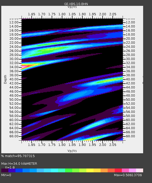
KBS IRIS/GEOFON/AWI Station Ny Alesund, Spitsbergen - Earthquake Result Viewer

Earthquake location: Queen Charlotte Islands Region
Earthquake latitude/longitude: 54.8/-134.2
Earthquake time(UTC): 2004/06/28 (180) 09:49:47 GMT
Earthquake Depth: 20 km
Earthquake Magnitude: 5.9 MB, 6.8 MS, 6.8 MW, 6.8 MW
Earthquake Catalog/Contributor: WHDF/NEIC
Network: GE GEOFON
Station: KBS IRIS/GEOFON/AWI Station Ny Alesund, Spitsbergen
Lat/Lon: 78.93 N/11.94 E
Elevation: 77 m
Distance: 45.0 deg
Az: 8.748 deg
Baz: 332.903 deg
Ray Param: 0.07153008
Estimated Moho Depth: 34.0 km
Estimated Crust Vp/Vs: 1.60
Assumed Crust Vp: 6.287 km/s
Estimated Crust Vs: 3.93 km/s
Estimated Crust Poisson's Ratio: 0.18
Radial Match: 95.787315 %
Radial Bump: 246
Transverse Match: 83.47096 %
Transverse Bump: 400
SOD ConfigId: 2459
Insert Time: 2010-03-09 05:03:33.610 +0000
GWidth: 2.5
Max Bumps: 400
Tol: 0.001

Signal To Noise

ChannelStoNSTALTA
GE:KBS:10:BHN:20040628T09:57:30.26001Z12.8308057.428614E-75.7896713E-8
GE:KBS:10:BHE:20040628T09:57:30.26001Z10.9867395.028187E-74.5765965E-8
GE:KBS:10:BHZ:20040628T09:57:30.26001Z15.0742941.5102682E-61.0018832E-7
Arrivals
Ps3.5 SECOND
PpPs13 SECOND
PsPs/PpSs17 SECOND