You are here: Home > Network List > GE - GEOFON Stations List
> Station KBS IRIS/GEOFON/AWI Station Ny Alesund, Spitsbergen > Earthquake Result Viewer
KBS IRIS/GEOFON/AWI Station Ny Alesund, Spitsbergen - Earthquake Result Viewer
| Earthquake location: |
Guatemala |
| Earthquake latitude/longitude: |
14.4/-91.5 |
| Earthquake time(UTC): |
1998/01/10 (010) 08:20:05 GMT |
| Earthquake Depth: |
33 km |
| Earthquake Magnitude: |
6.1 MB, 6.2 MS, 6.6 UNKNOWN, 6.6 ME |
| Earthquake Catalog/Contributor: |
WHDF/NEIC |
|
| Network: |
GE GEOFON |
| Station: |
KBS IRIS/GEOFON/AWI Station Ny Alesund, Spitsbergen |
| Lat/Lon: |
78.93 N/11.94 E |
| Elevation: |
77 m |
|
| Distance: |
78.5 deg |
| Az: |
11.062 deg |
| Baz: |
285.886 deg |
| Ray Param: |
0.049521778 |
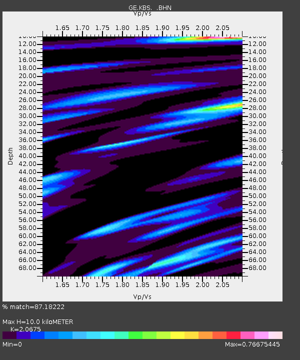
| Estimated Moho Depth: |
10.0 km |
| Estimated Crust Vp/Vs: |
2.07 |
| Assumed Crust Vp: |
6.287 km/s |
| Estimated Crust Vs: |
3.041 km/s |
| Estimated Crust Poisson's Ratio: |
0.35 |
|
| Radial Match: |
87.18222 % |
| Radial Bump: |
400 |
| Transverse Match: |
71.044556 % |
| Transverse Bump: |
400 |
| SOD ConfigId: |
4480 |
| Insert Time: |
2010-03-09 05:03:34.789 +0000 |
| GWidth: |
2.5 |
| Max Bumps: |
400 |
| Tol: |
0.001 |
|

Signal To Noise
| Channel | StoN | STA | LTA |
| GE:KBS: :BHN:19980110T08:31:32.678027Z | 4.0911074 | 7.536761E-7 | 1.84223E-7 |
| GE:KBS: :BHE:19980110T08:31:32.678027Z | 1.3381858 | 1.8376414E-7 | 1.3732334E-7 |
| GE:KBS: :BHZ:19980110T08:31:32.678027Z | 2.6399715 | 4.24004E-7 | 1.6060932E-7 |
| Arrivals |
| Ps | 1.7 SECOND |
| PpPs | 4.8 SECOND |
| PsPs/PpSs | 6.5 SECOND |


