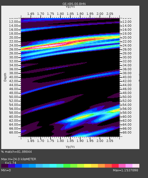
KBS IRIS/GEOFON/AWI Station Ny Alesund, Spitsbergen - Earthquake Result Viewer

Earthquake location: Near East Coast Of Honshu, Japan
Earthquake latitude/longitude: 38.1/142.1
Earthquake time(UTC): 2005/12/02 (336) 13:13:09 GMT
Earthquake Depth: 29 km
Earthquake Magnitude: 6.1 MB, 6.3 MS, 6.5 MW, 6.4 MW
Earthquake Catalog/Contributor: WHDF/NEIC
Network: GE GEOFON
Station: KBS IRIS/GEOFON/AWI Station Ny Alesund, Spitsbergen
Lat/Lon: 78.93 N/11.94 E
Elevation: 77 m
Distance: 59.7 deg
Az: 350.151 deg
Baz: 44.277 deg
Ray Param: 0.061960027
Estimated Moho Depth: 24.0 km
Estimated Crust Vp/Vs: 1.74
Assumed Crust Vp: 6.287 km/s
Estimated Crust Vs: 3.614 km/s
Estimated Crust Poisson's Ratio: 0.25
Radial Match: 81.89844 %
Radial Bump: 400
Transverse Match: 63.76107 %
Transverse Bump: 400
SOD ConfigId: 2422
Insert Time: 2010-03-09 05:03:43.671 +0000
GWidth: 2.5
Max Bumps: 400
Tol: 0.001

Signal To Noise

ChannelStoNSTALTA
GE:KBS:00:BHN:20051202T13:22:40.548015Z2.55956651.060889E-64.1447993E-7
GE:KBS:00:BHE:20051202T13:22:40.548015Z2.36140181.7097472E-67.2403907E-7
GE:KBS:00:BHZ:20051202T13:22:40.548015Z8.3629384.0045343E-64.7884305E-7
Arrivals
Ps3.0 SECOND
PpPs10.0 SECOND
PsPs/PpSs13 SECOND