You are here: Home > Network List > G - GEOSCOPE Stations List
> Station RER Riviere de l'Est, La Reunion (Indian Ocean) > Earthquake Result Viewer
RER Riviere de l'Est, La Reunion (Indian Ocean) - Earthquake Result Viewer
| Earthquake location: |
South Shetland Islands |
| Earthquake latitude/longitude: |
-61.8/-55.6 |
| Earthquake time(UTC): |
2021/01/23 (023) 23:36:50 GMT |
| Earthquake Depth: |
7.8 km |
| Earthquake Magnitude: |
7.0 mww |
| Earthquake Catalog/Contributor: |
NEIC PDE/us |
|
| Network: |
G GEOSCOPE |
| Station: |
RER Riviere de l'Est, La Reunion (Indian Ocean) |
| Lat/Lon: |
21.16 S/55.75 E |
| Elevation: |
834 m |
|
| Distance: |
81.1 deg |
| Az: |
118.327 deg |
| Baz: |
206.569 deg |
| Ray Param: |
0.047847837 |
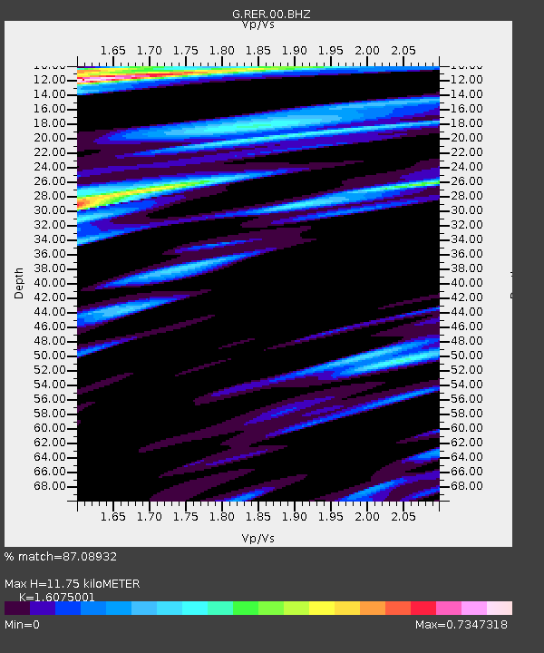
| Estimated Moho Depth: |
11.75 km |
| Estimated Crust Vp/Vs: |
1.61 |
| Assumed Crust Vp: |
4.73 km/s |
| Estimated Crust Vs: |
2.942 km/s |
| Estimated Crust Poisson's Ratio: |
0.18 |
|
| Radial Match: |
87.08932 % |
| Radial Bump: |
400 |
| Transverse Match: |
65.52508 % |
| Transverse Bump: |
400 |
| SOD ConfigId: |
23341671 |
| Insert Time: |
2021-02-07 00:40:18.139 +0000 |
| GWidth: |
2.5 |
| Max Bumps: |
400 |
| Tol: |
0.001 |
|
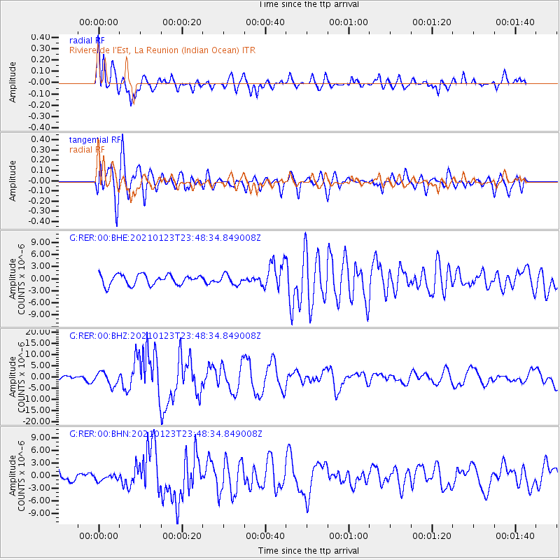
Signal To Noise
| Channel | StoN | STA | LTA |
| G:RER:00:BHZ:20210123T23:48:34.849008Z | 1.9603236 | 2.9267596E-6 | 1.4929983E-6 |
| G:RER:00:BHN:20210123T23:48:34.849008Z | 0.68368953 | 6.960964E-7 | 1.0181469E-6 |
| G:RER:00:BHE:20210123T23:48:34.849008Z | 0.94907707 | 1.1935675E-6 | 1.2576087E-6 |
| Arrivals |
| Ps | 1.5 SECOND |
| PpPs | 6.4 SECOND |
| PsPs/PpSs | 7.9 SECOND |


