You are here: Home > Network List > PR - Puerto Rico Seismic Network (PRSN) & Puerto Rico Strong Motion Program (PRSMP) Stations List
> Station MLPR PRSN > Earthquake Result Viewer
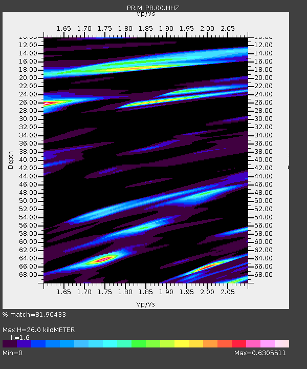
MLPR PRSN - Earthquake Result Viewer
| Earthquake location: |
South Shetland Islands |
| Earthquake latitude/longitude: |
-61.8/-55.6 |
| Earthquake time(UTC): |
2021/01/23 (023) 23:36:50 GMT |
| Earthquake Depth: |
7.8 km |
| Earthquake Magnitude: |
7.0 mww |
| Earthquake Catalog/Contributor: |
NEIC PDE/us |
|
| Network: |
PR Puerto Rico Seismic Network (PRSN) & Puerto Rico Strong Motion Program (PRSMP) |
| Station: |
MLPR PRSN |
| Lat/Lon: |
17.97 N/67.04 W |
| Elevation: |
31 m |
|
| Distance: |
80.1 deg |
| Az: |
348.907 deg |
| Baz: |
174.499 deg |
| Ray Param: |
0.048538577 |
| Estimated Moho Depth: |
26.0 km |
| Estimated Crust Vp/Vs: |
1.60 |
| Assumed Crust Vp: |
4.082 km/s |
| Estimated Crust Vs: |
2.551 km/s |
| Estimated Crust Poisson's Ratio: |
0.18 |
|
| Radial Match: |
81.90433 % |
| Radial Bump: |
400 |
| Transverse Match: |
78.054184 % |
| Transverse Bump: |
400 |
| SOD ConfigId: |
23341671 |
| Insert Time: |
2021-02-07 00:42:41.728 +0000 |
| GWidth: |
2.5 |
| Max Bumps: |
400 |
| Tol: |
0.001 |
|

Signal To Noise
| Channel | StoN | STA | LTA |
| PR:MLPR:00:HHZ:20210123T23:48:29.520029Z | 5.4408894 | 1.3562886E-6 | 2.49277E-7 |
| PR:MLPR:00:HH1:20210123T23:48:29.520029Z | 1.8062516 | 3.7524495E-7 | 2.0774789E-7 |
| PR:MLPR:00:HH2:20210123T23:48:29.520029Z | 2.278998 | 3.6108975E-7 | 1.5844233E-7 |
| Arrivals |
| Ps | 3.9 SECOND |
| PpPs | 16 SECOND |
| PsPs/PpSs | 20 SECOND |


