You are here: Home > Network List > S1 - Australian Seismometers in Schools Stations List
> Station AUMTS Mt Stromlo > Earthquake Result Viewer
AUMTS Mt Stromlo - Earthquake Result Viewer
| Earthquake location: |
South Shetland Islands |
| Earthquake latitude/longitude: |
-61.8/-55.6 |
| Earthquake time(UTC): |
2021/01/23 (023) 23:36:50 GMT |
| Earthquake Depth: |
7.8 km |
| Earthquake Magnitude: |
7.0 mww |
| Earthquake Catalog/Contributor: |
NEIC PDE/us |
|
| Network: |
S1 Australian Seismometers in Schools |
| Station: |
AUMTS Mt Stromlo |
| Lat/Lon: |
35.32 S/149.00 E |
| Elevation: |
667 m |
|
| Distance: |
81.1 deg |
| Az: |
200.117 deg |
| Baz: |
168.494 deg |
| Ray Param: |
0.04780155 |
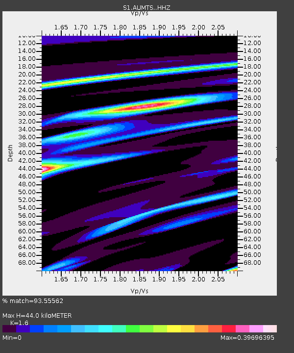
| Estimated Moho Depth: |
44.0 km |
| Estimated Crust Vp/Vs: |
1.60 |
| Assumed Crust Vp: |
6.633 km/s |
| Estimated Crust Vs: |
4.146 km/s |
| Estimated Crust Poisson's Ratio: |
0.18 |
|
| Radial Match: |
93.55562 % |
| Radial Bump: |
327 |
| Transverse Match: |
75.69414 % |
| Transverse Bump: |
400 |
| SOD ConfigId: |
23341671 |
| Insert Time: |
2021-02-07 00:43:06.527 +0000 |
| GWidth: |
2.5 |
| Max Bumps: |
400 |
| Tol: |
0.001 |
|

Signal To Noise
| Channel | StoN | STA | LTA |
| S1:AUMTS: :HHZ:20210123T23:48:35.260019Z | 2.4601164 | 1.243709E-6 | 5.055488E-7 |
| S1:AUMTS: :HHN:20210123T23:48:35.260019Z | 1.0222578 | 4.1673974E-7 | 4.07666E-7 |
| S1:AUMTS: :HHE:20210123T23:48:35.260019Z | 0.6401752 | 2.1455936E-7 | 3.3515724E-7 |
| Arrivals |
| Ps | 4.1 SECOND |
| PpPs | 17 SECOND |
| PsPs/PpSs | 21 SECOND |


