You are here: Home > Network List > WI - West Indies IPGP Network Stations List
> Station BIM Morne Bigot, Anses d'Arlets, Martinique > Earthquake Result Viewer
BIM Morne Bigot, Anses d'Arlets, Martinique - Earthquake Result Viewer

| Earthquake location: |
South Shetland Islands |
| Earthquake latitude/longitude: |
-61.8/-55.6 |
| Earthquake time(UTC): |
2021/01/23 (023) 23:36:50 GMT |
| Earthquake Depth: |
7.8 km |
| Earthquake Magnitude: |
7.0 mww |
| Earthquake Catalog/Contributor: |
NEIC PDE/us |
|
| Network: |
WI West Indies IPGP Network |
| Station: |
BIM Morne Bigot, Anses d'Arlets, Martinique |
| Lat/Lon: |
14.52 N/61.07 W |
| Elevation: |
391 m |
|
| Distance: |
76.2 deg |
| Az: |
354.509 deg |
| Baz: |
177.314 deg |
| Ray Param: |
0.05113769 |
| Estimated Moho Depth: |
57.5 km |
| Estimated Crust Vp/Vs: |
1.88 |
| Assumed Crust Vp: |
5.88 km/s |
| Estimated Crust Vs: |
3.136 km/s |
| Estimated Crust Poisson's Ratio: |
0.30 |
|
| Radial Match: |
93.47923 % |
| Radial Bump: |
400 |
| Transverse Match: |
82.393295 % |
| Transverse Bump: |
400 |
| SOD ConfigId: |
23341671 |
| Insert Time: |
2021-02-07 00:43:57.647 +0000 |
| GWidth: |
2.5 |
| Max Bumps: |
400 |
| Tol: |
0.001 |
|
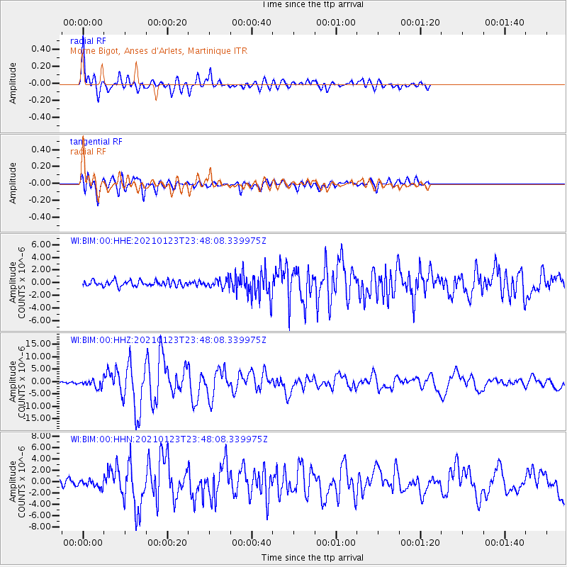
Signal To Noise
| Channel | StoN | STA | LTA |
| WI:BIM:00:HHZ:20210123T23:48:08.339975Z | 4.9645257 | 1.5393642E-6 | 3.1007278E-7 |
| WI:BIM:00:HHN:20210123T23:48:08.339975Z | 1.182099 | 6.590312E-7 | 5.575093E-7 |
| WI:BIM:00:HHE:20210123T23:48:08.339975Z | 1.4598655 | 6.463818E-7 | 4.4276806E-7 |
| Arrivals |
| Ps | 8.8 SECOND |
| PpPs | 27 SECOND |
| PsPs/PpSs | 36 SECOND |


