You are here: Home > Network List > WI - West Indies IPGP Network Stations List
> Station MAGL Barre de l'ile, Marie-Galante, Guadeloupe > Earthquake Result Viewer
MAGL Barre de l'ile, Marie-Galante, Guadeloupe - Earthquake Result Viewer
| Earthquake location: |
South Shetland Islands |
| Earthquake latitude/longitude: |
-61.8/-55.6 |
| Earthquake time(UTC): |
2021/01/23 (023) 23:36:50 GMT |
| Earthquake Depth: |
7.8 km |
| Earthquake Magnitude: |
7.0 mww |
| Earthquake Catalog/Contributor: |
NEIC PDE/us |
|
| Network: |
WI West Indies IPGP Network |
| Station: |
MAGL Barre de l'ile, Marie-Galante, Guadeloupe |
| Lat/Lon: |
15.95 N/61.28 W |
| Elevation: |
159 m |
|
| Distance: |
77.7 deg |
| Az: |
354.365 deg |
| Baz: |
177.225 deg |
| Ray Param: |
0.050180107 |
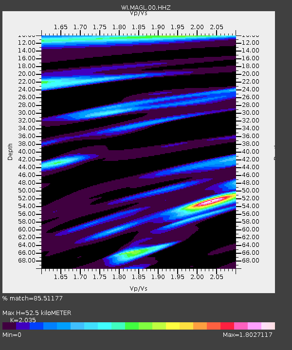
| Estimated Moho Depth: |
52.5 km |
| Estimated Crust Vp/Vs: |
2.04 |
| Assumed Crust Vp: |
5.88 km/s |
| Estimated Crust Vs: |
2.89 km/s |
| Estimated Crust Poisson's Ratio: |
0.34 |
|
| Radial Match: |
85.51177 % |
| Radial Bump: |
400 |
| Transverse Match: |
72.62484 % |
| Transverse Bump: |
400 |
| SOD ConfigId: |
23341671 |
| Insert Time: |
2021-02-07 00:44:05.198 +0000 |
| GWidth: |
2.5 |
| Max Bumps: |
400 |
| Tol: |
0.001 |
|

Signal To Noise
| Channel | StoN | STA | LTA |
| WI:MAGL:00:HHZ:20210123T23:48:16.380014Z | 1.9574126 | 1.9319755E-6 | 9.870047E-7 |
| WI:MAGL:00:HHN:20210123T23:48:16.380014Z | 1.5084033 | 1.5611267E-6 | 1.0349531E-6 |
| WI:MAGL:00:HHE:20210123T23:48:16.380014Z | 0.95518297 | 1.106284E-6 | 1.1581907E-6 |
| Arrivals |
| Ps | 9.4 SECOND |
| PpPs | 27 SECOND |
| PsPs/PpSs | 36 SECOND |


