You are here: Home > Network List > EC - Ecuador Seismic Network Stations List
> Station SLOR TEMP - COTO > Earthquake Result Viewer
SLOR TEMP - COTO - Earthquake Result Viewer
| Earthquake location: |
Chile-Argentina Border Region |
| Earthquake latitude/longitude: |
-33.4/-70.2 |
| Earthquake time(UTC): |
2021/01/24 (024) 00:07:45 GMT |
| Earthquake Depth: |
111 km |
| Earthquake Magnitude: |
5.8 Mww |
| Earthquake Catalog/Contributor: |
NEIC PDE/us |
|
| Network: |
EC Ecuador Seismic Network |
| Station: |
SLOR TEMP - COTO |
| Lat/Lon: |
0.73 S/78.50 W |
| Elevation: |
3600 m |
|
| Distance: |
33.4 deg |
| Az: |
344.834 deg |
| Baz: |
167.351 deg |
| Ray Param: |
0.07792729 |
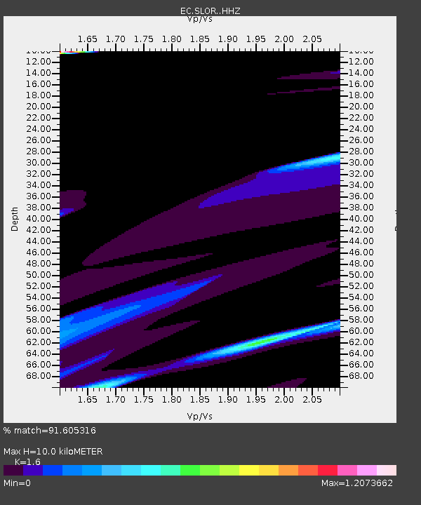
| Estimated Moho Depth: |
10.0 km |
| Estimated Crust Vp/Vs: |
1.60 |
| Assumed Crust Vp: |
6.472 km/s |
| Estimated Crust Vs: |
4.045 km/s |
| Estimated Crust Poisson's Ratio: |
0.18 |
|
| Radial Match: |
91.605316 % |
| Radial Bump: |
332 |
| Transverse Match: |
66.59692 % |
| Transverse Bump: |
384 |
| SOD ConfigId: |
23341671 |
| Insert Time: |
2021-02-07 01:12:55.073 +0000 |
| GWidth: |
2.5 |
| Max Bumps: |
400 |
| Tol: |
0.001 |
|

Signal To Noise
| Channel | StoN | STA | LTA |
| EC:SLOR: :HHZ:20210124T00:13:42.485013Z | 1.4095283 | 1.37505E-5 | 9.755392E-6 |
| EC:SLOR: :HHN:20210124T00:13:42.485013Z | 1.4367046 | 1.2370596E-5 | 8.6103955E-6 |
| EC:SLOR: :HHE:20210124T00:13:42.485013Z | 0.53222257 | 2.1378507E-6 | 4.016836E-6 |
| Arrivals |
| Ps | 1.0 SECOND |
| PpPs | 3.7 SECOND |
| PsPs/PpSs | 4.7 SECOND |


