You are here: Home > Network List > UU - University of Utah Regional Network Stations List
> Station KNB Kanab, UT, USA > Earthquake Result Viewer
KNB Kanab, UT, USA - Earthquake Result Viewer
| Earthquake location: |
Off East Coast Of Honshu, Japan |
| Earthquake latitude/longitude: |
37.5/144.0 |
| Earthquake time(UTC): |
2017/10/06 (279) 07:59:33 GMT |
| Earthquake Depth: |
10 km |
| Earthquake Magnitude: |
6.0 Mww |
| Earthquake Catalog/Contributor: |
NEIC PDE/us |
|
| Network: |
UU University of Utah Regional Network |
| Station: |
KNB Kanab, UT, USA |
| Lat/Lon: |
37.02 N/112.82 W |
| Elevation: |
1715 m |
|
| Distance: |
77.4 deg |
| Az: |
52.969 deg |
| Baz: |
307.496 deg |
| Ray Param: |
0.05032725 |
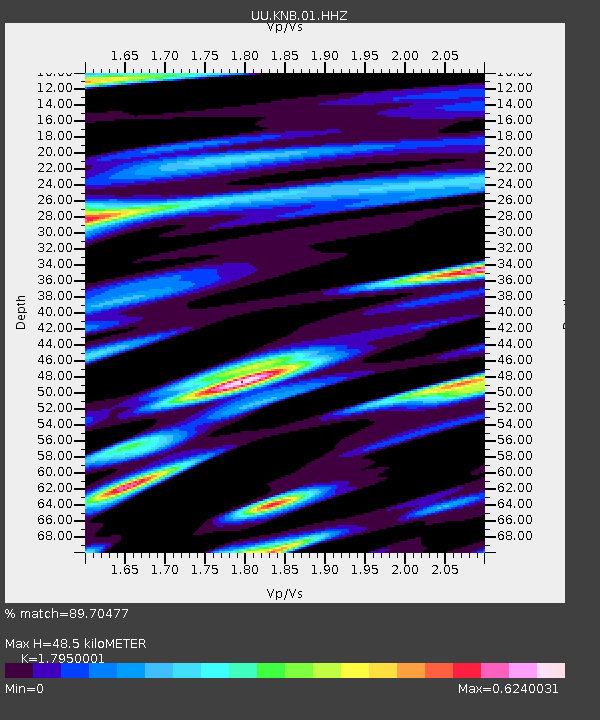
| Estimated Moho Depth: |
48.5 km |
| Estimated Crust Vp/Vs: |
1.80 |
| Assumed Crust Vp: |
6.194 km/s |
| Estimated Crust Vs: |
3.451 km/s |
| Estimated Crust Poisson's Ratio: |
0.27 |
|
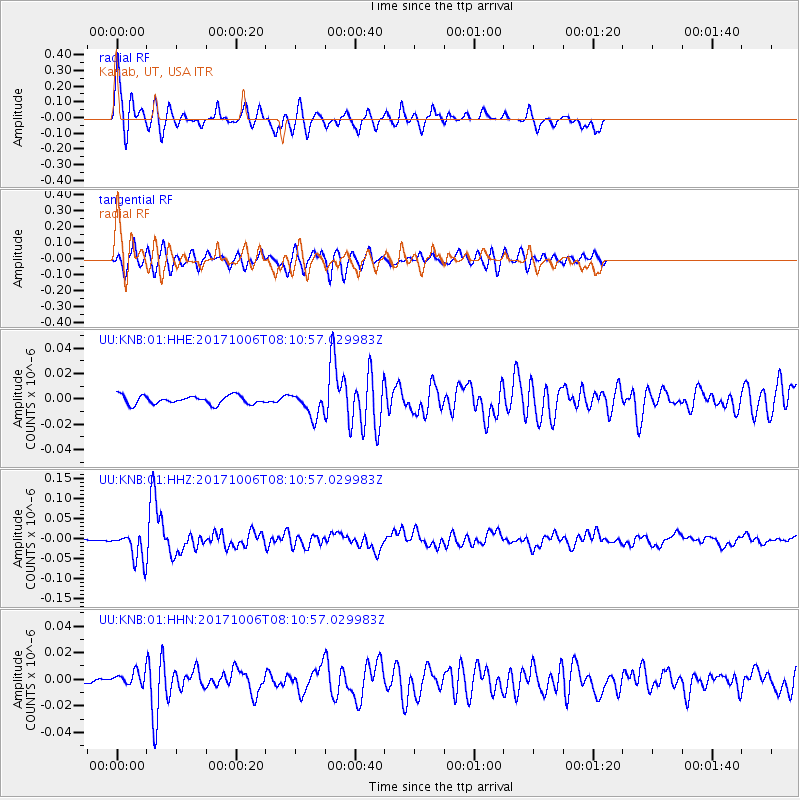
| Radial Match: |
89.70477 % |
| Radial Bump: |
382 |
| Transverse Match: |
76.951416 % |
| Transverse Bump: |
373 |
| SOD ConfigId: |
2364251 |
| Insert Time: |
2017-10-20 08:09:31.109 +0000 |
| GWidth: |
2.5 |
| Max Bumps: |
400 |
| Tol: |
0.001 |
|
Signal To Noise
| Channel | StoN | STA | LTA |
| UU:KNB:01:HHZ:20171006T08:10:57.029983Z | 9.002814 | 3.563357E-8 | 3.9580477E-9 |
| UU:KNB:01:HHN:20171006T08:10:57.029983Z | 1.2935632 | 4.9640625E-9 | 3.8375108E-9 |
| UU:KNB:01:HHE:20171006T08:10:57.029983Z | 2.8441994 | 9.414179E-9 | 3.3099574E-9 |
| Arrivals |
| Ps | 6.4 SECOND |
| PpPs | 21 SECOND |
| PsPs/PpSs | 28 SECOND |


