You are here: Home > Network List > UU - University of Utah Regional Network Stations List
> Station SZCU Shurtz Canyon, UT, USA > Earthquake Result Viewer
SZCU Shurtz Canyon, UT, USA - Earthquake Result Viewer
| Earthquake location: |
Off East Coast Of Honshu, Japan |
| Earthquake latitude/longitude: |
37.5/144.0 |
| Earthquake time(UTC): |
2017/10/06 (279) 07:59:33 GMT |
| Earthquake Depth: |
10 km |
| Earthquake Magnitude: |
6.0 Mww |
| Earthquake Catalog/Contributor: |
NEIC PDE/us |
|
| Network: |
UU University of Utah Regional Network |
| Station: |
SZCU Shurtz Canyon, UT, USA |
| Lat/Lon: |
37.60 N/113.09 W |
| Elevation: |
2026 m |
|
| Distance: |
76.9 deg |
| Az: |
52.629 deg |
| Baz: |
307.26 deg |
| Ray Param: |
0.05067563 |
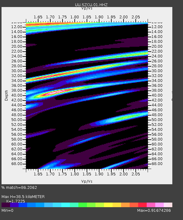
| Estimated Moho Depth: |
38.5 km |
| Estimated Crust Vp/Vs: |
1.72 |
| Assumed Crust Vp: |
6.194 km/s |
| Estimated Crust Vs: |
3.596 km/s |
| Estimated Crust Poisson's Ratio: |
0.25 |
|
| Radial Match: |
86.2062 % |
| Radial Bump: |
400 |
| Transverse Match: |
68.79167 % |
| Transverse Bump: |
400 |
| SOD ConfigId: |
2364251 |
| Insert Time: |
2017-10-20 08:09:50.904 +0000 |
| GWidth: |
2.5 |
| Max Bumps: |
400 |
| Tol: |
0.001 |
|

Signal To Noise
| Channel | StoN | STA | LTA |
| UU:SZCU:01:HHZ:20171006T08:10:54.13002Z | 6.900107 | 2.0971253E-8 | 3.039265E-9 |
| UU:SZCU:01:HHN:20171006T08:10:54.13002Z | 3.8128538 | 5.5539946E-9 | 1.4566502E-9 |
| UU:SZCU:01:HHE:20171006T08:10:54.13002Z | 2.3879697 | 5.442981E-9 | 2.279334E-9 |
| Arrivals |
| Ps | 4.6 SECOND |
| PpPs | 16 SECOND |
| PsPs/PpSs | 21 SECOND |


