You are here: Home > Network List > TA - USArray Transportable Network (new EarthScope stations) Stations List
> Station I17K Unalakleet, AK, USA > Earthquake Result Viewer
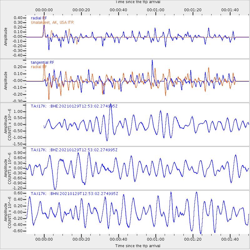
I17K Unalakleet, AK, USA - Earthquake Result Viewer
*The percent match for this event was below the threshold and hence no stack was calculated.
| Earthquake location: |
Panama-Costa Rica Border Region |
| Earthquake latitude/longitude: |
8.2/-83.0 |
| Earthquake time(UTC): |
2021/01/29 (029) 12:41:39 GMT |
| Earthquake Depth: |
10 km |
| Earthquake Magnitude: |
5.6 Mww |
| Earthquake Catalog/Contributor: |
NEIC PDE/us |
|
| Network: |
TA USArray Transportable Network (new EarthScope stations) |
| Station: |
I17K Unalakleet, AK, USA |
| Lat/Lon: |
63.89 N/160.70 W |
| Elevation: |
105 m |
|
| Distance: |
77.3 deg |
| Az: |
333.686 deg |
| Baz: |
97.422 deg |
| Ray Param: |
$rayparam |
*The percent match for this event was below the threshold and hence was not used in the summary stack. |
|
| Radial Match: |
43.99256 % |
| Radial Bump: |
360 |
| Transverse Match: |
54.63306 % |
| Transverse Bump: |
327 |
| SOD ConfigId: |
23341671 |
| Insert Time: |
2021-02-12 13:58:09.304 +0000 |
| GWidth: |
2.5 |
| Max Bumps: |
400 |
| Tol: |
0.001 |
|
Signal To Noise
| Channel | StoN | STA | LTA |
| TA:I17K: :BHZ:20210129T12:53:02.274995Z | 1.3505323 | 3.9534217E-7 | 2.9273065E-7 |
| TA:I17K: :BHN:20210129T12:53:02.274995Z | 0.4504233 | 9.597058E-8 | 2.1306752E-7 |
| TA:I17K: :BHE:20210129T12:53:02.274995Z | 2.7771645 | 6.3573447E-7 | 2.2891494E-7 |
| Arrivals |
| Ps | |
| PpPs | |
| PsPs/PpSs | |


