You are here: Home > Network List > US - United States National Seismic Network Stations List
> Station AGMN Agassiz National Wildlife Refuge, Minnesota, USA > Earthquake Result Viewer
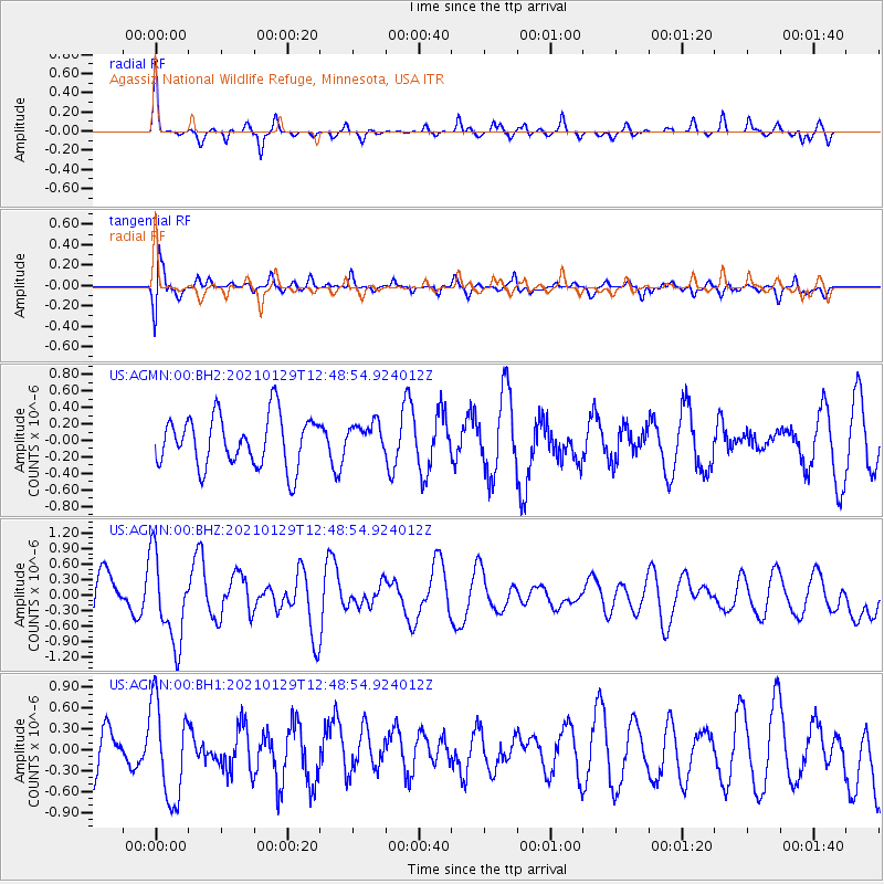
AGMN Agassiz National Wildlife Refuge, Minnesota, USA - Earthquake Result Viewer
*The percent match for this event was below the threshold and hence no stack was calculated.
| Earthquake location: |
Panama-Costa Rica Border Region |
| Earthquake latitude/longitude: |
8.2/-83.0 |
| Earthquake time(UTC): |
2021/01/29 (029) 12:41:39 GMT |
| Earthquake Depth: |
10 km |
| Earthquake Magnitude: |
5.6 Mww |
| Earthquake Catalog/Contributor: |
NEIC PDE/us |
|
| Network: |
US United States National Seismic Network |
| Station: |
AGMN Agassiz National Wildlife Refuge, Minnesota, USA |
| Lat/Lon: |
48.30 N/95.86 W |
| Elevation: |
351 m |
|
| Distance: |
41.4 deg |
| Az: |
346.985 deg |
| Baz: |
160.497 deg |
| Ray Param: |
$rayparam |
*The percent match for this event was below the threshold and hence was not used in the summary stack. |
|
| Radial Match: |
66.263374 % |
| Radial Bump: |
256 |
| Transverse Match: |
75.710976 % |
| Transverse Bump: |
400 |
| SOD ConfigId: |
23341671 |
| Insert Time: |
2021-02-12 13:59:16.626 +0000 |
| GWidth: |
2.5 |
| Max Bumps: |
400 |
| Tol: |
0.001 |
|
Signal To Noise
| Channel | StoN | STA | LTA |
| US:AGMN:00:BHZ:20210129T12:48:54.924012Z | 1.9406037 | 8.3722784E-7 | 4.3142649E-7 |
| US:AGMN:00:BH1:20210129T12:48:54.924012Z | 2.5113893 | 7.008906E-7 | 2.7908484E-7 |
| US:AGMN:00:BH2:20210129T12:48:54.924012Z | 0.5823021 | 1.7986405E-7 | 3.088844E-7 |
| Arrivals |
| Ps | |
| PpPs | |
| PsPs/PpSs | |


