You are here: Home > Network List > US - United States National Seismic Network Stations List
> Station MNTX Cornudas Mountains, Texas, USA > Earthquake Result Viewer
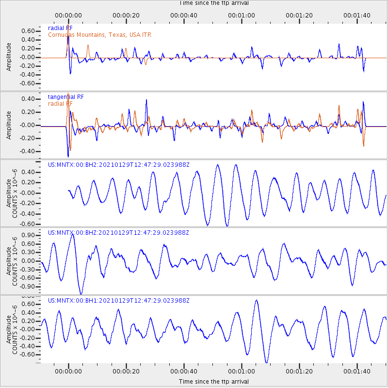
MNTX Cornudas Mountains, Texas, USA - Earthquake Result Viewer
*The percent match for this event was below the threshold and hence no stack was calculated.
| Earthquake location: |
Panama-Costa Rica Border Region |
| Earthquake latitude/longitude: |
8.2/-83.0 |
| Earthquake time(UTC): |
2021/01/29 (029) 12:41:39 GMT |
| Earthquake Depth: |
10 km |
| Earthquake Magnitude: |
5.6 Mww |
| Earthquake Catalog/Contributor: |
NEIC PDE/us |
|
| Network: |
US United States National Seismic Network |
| Station: |
MNTX Cornudas Mountains, Texas, USA |
| Lat/Lon: |
31.70 N/105.38 W |
| Elevation: |
404 m |
|
| Distance: |
31.3 deg |
| Az: |
321.323 deg |
| Baz: |
133.469 deg |
| Ray Param: |
$rayparam |
*The percent match for this event was below the threshold and hence was not used in the summary stack. |
|
| Radial Match: |
60.5958 % |
| Radial Bump: |
400 |
| Transverse Match: |
68.13395 % |
| Transverse Bump: |
365 |
| SOD ConfigId: |
23341671 |
| Insert Time: |
2021-02-12 13:59:32.551 +0000 |
| GWidth: |
2.5 |
| Max Bumps: |
400 |
| Tol: |
0.001 |
|
Signal To Noise
| Channel | StoN | STA | LTA |
| US:MNTX:00:BHZ:20210129T12:47:29.023988Z | 3.8200636 | 7.405233E-7 | 1.9385105E-7 |
| US:MNTX:00:BH1:20210129T12:47:29.023988Z | 0.80530787 | 1.6533566E-7 | 2.053074E-7 |
| US:MNTX:00:BH2:20210129T12:47:29.023988Z | 1.5924385 | 2.610174E-7 | 1.6391051E-7 |
| Arrivals |
| Ps | |
| PpPs | |
| PsPs/PpSs | |


