You are here: Home > Network List > UU - University of Utah Regional Network Stations List
> Station CCUT Cedar City, UT, USA > Earthquake Result Viewer
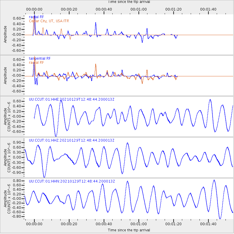
CCUT Cedar City, UT, USA - Earthquake Result Viewer
*The percent match for this event was below the threshold and hence no stack was calculated.
| Earthquake location: |
Panama-Costa Rica Border Region |
| Earthquake latitude/longitude: |
8.2/-83.0 |
| Earthquake time(UTC): |
2021/01/29 (029) 12:41:39 GMT |
| Earthquake Depth: |
10 km |
| Earthquake Magnitude: |
5.6 Mww |
| Earthquake Catalog/Contributor: |
NEIC PDE/us |
|
| Network: |
UU University of Utah Regional Network |
| Station: |
CCUT Cedar City, UT, USA |
| Lat/Lon: |
37.55 N/113.36 W |
| Elevation: |
2127 m |
|
| Distance: |
40.1 deg |
| Az: |
321.397 deg |
| Baz: |
129.004 deg |
| Ray Param: |
$rayparam |
*The percent match for this event was below the threshold and hence was not used in the summary stack. |
|
| Radial Match: |
86.472084 % |
| Radial Bump: |
278 |
| Transverse Match: |
64.914 % |
| Transverse Bump: |
400 |
| SOD ConfigId: |
23341671 |
| Insert Time: |
2021-02-12 13:59:45.202 +0000 |
| GWidth: |
2.5 |
| Max Bumps: |
400 |
| Tol: |
0.001 |
|
Signal To Noise
| Channel | StoN | STA | LTA |
| UU:CCUT:01:HHZ:20210129T12:48:44.200013Z | 1.6567438 | 4.7751973E-7 | 2.882279E-7 |
| UU:CCUT:01:HHN:20210129T12:48:44.200013Z | 1.2051213 | 2.1525672E-7 | 1.7861831E-7 |
| UU:CCUT:01:HHE:20210129T12:48:44.200013Z | 0.508211 | 1.9116229E-7 | 3.7614745E-7 |
| Arrivals |
| Ps | |
| PpPs | |
| PsPs/PpSs | |


