You are here: Home > Network List > US - United States National Seismic Network Stations List
> Station NEW Newport, Washington, USA > Earthquake Result Viewer
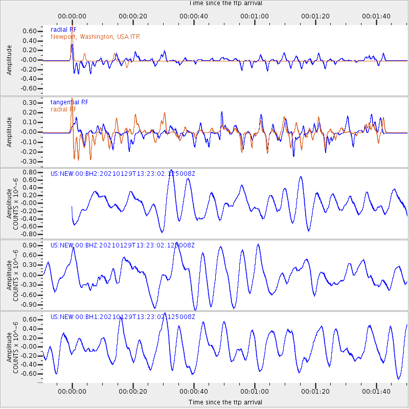
NEW Newport, Washington, USA - Earthquake Result Viewer
*The percent match for this event was below the threshold and hence no stack was calculated.
| Earthquake location: |
Panama-Costa Rica Border Region |
| Earthquake latitude/longitude: |
8.3/-83.0 |
| Earthquake time(UTC): |
2021/01/29 (029) 13:14:44 GMT |
| Earthquake Depth: |
10 km |
| Earthquake Magnitude: |
5.5 Mww |
| Earthquake Catalog/Contributor: |
NEIC PDE/us |
|
| Network: |
US United States National Seismic Network |
| Station: |
NEW Newport, Washington, USA |
| Lat/Lon: |
48.26 N/117.12 W |
| Elevation: |
760 m |
|
| Distance: |
49.2 deg |
| Az: |
330.277 deg |
| Baz: |
132.745 deg |
| Ray Param: |
$rayparam |
*The percent match for this event was below the threshold and hence was not used in the summary stack. |
|
| Radial Match: |
47.747314 % |
| Radial Bump: |
400 |
| Transverse Match: |
47.1911 % |
| Transverse Bump: |
400 |
| SOD ConfigId: |
23341671 |
| Insert Time: |
2021-02-12 14:29:50.674 +0000 |
| GWidth: |
2.5 |
| Max Bumps: |
400 |
| Tol: |
0.001 |
|
Signal To Noise
| Channel | StoN | STA | LTA |
| US:NEW:00:BHZ:20210129T13:23:02.125008Z | 1.4617076 | 4.5617566E-7 | 3.1208407E-7 |
| US:NEW:00:BH1:20210129T13:23:02.125008Z | 0.32224452 | 1.0829239E-7 | 3.3605656E-7 |
| US:NEW:00:BH2:20210129T13:23:02.125008Z | 2.636385 | 5.767261E-7 | 2.1875641E-7 |
| Arrivals |
| Ps | |
| PpPs | |
| PsPs/PpSs | |


