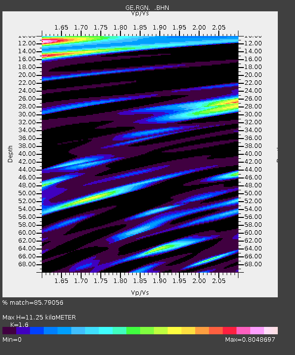
RGN GRSN/GEOFON Station Ruegen, Germany - Earthquake Result Viewer

Earthquake location: Rat Islands, Aleutian Islands
Earthquake latitude/longitude: 51.6/175.2
Earthquake time(UTC): 1998/08/20 (232) 15:00:08 GMT
Earthquake Depth: 33 km
Earthquake Magnitude: 5.6 MB, 6.0 MS, 6.2 UNKNOWN, 6.2 MW
Earthquake Catalog/Contributor: WHDF/NEIC
Network: GE GEOFON
Station: RGN GRSN/GEOFON Station Ruegen, Germany
Lat/Lon: 54.55 N/13.32 E
Elevation: 15 m
Distance: 73.1 deg
Az: 349.113 deg
Baz: 11.661 deg
Ray Param: 0.053156424
Estimated Moho Depth: 11.25 km
Estimated Crust Vp/Vs: 1.60
Assumed Crust Vp: 6.1 km/s
Estimated Crust Vs: 3.812 km/s
Estimated Crust Poisson's Ratio: 0.18
Radial Match: 85.79056 %
Radial Bump: 400
Transverse Match: 75.61645 %
Transverse Bump: 400
SOD ConfigId: 4480
Insert Time: 2010-03-09 05:06:35.062 +0000
GWidth: 2.5
Max Bumps: 400
Tol: 0.001

Signal To Noise

ChannelStoNSTALTA
GE:RGN: :BHN:19980820T15:11:04.341028Z5.513191.8059277E-63.2756492E-7
GE:RGN: :BHE:19980820T15:11:04.341028Z2.13744247.831773E-73.6640864E-7
GE:RGN: :BHZ:19980820T15:11:04.341028Z1.06013944.775407E-74.5045084E-7
Arrivals
Ps1.1 SECOND
PpPs4.6 SECOND
PsPs/PpSs5.8 SECOND