You are here: Home > Network List > II - Global Seismograph Network (GSN - IRIS/IDA) Stations List
> Station WRAB Tennant Creek, NT, Australia > Earthquake Result Viewer
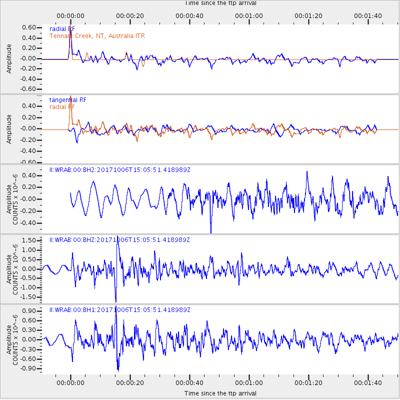
WRAB Tennant Creek, NT, Australia - Earthquake Result Viewer
*The percent match for this event was below the threshold and hence no stack was calculated.
| Earthquake location: |
Near East Coast Of Honshu, Japan |
| Earthquake latitude/longitude: |
37.1/141.2 |
| Earthquake time(UTC): |
2017/10/06 (279) 14:56:40 GMT |
| Earthquake Depth: |
47 km |
| Earthquake Magnitude: |
5.4 Mww |
| Earthquake Catalog/Contributor: |
NEIC PDE/us |
|
| Network: |
II Global Seismograph Network (GSN - IRIS/IDA) |
| Station: |
WRAB Tennant Creek, NT, Australia |
| Lat/Lon: |
19.93 S/134.36 E |
| Elevation: |
366 m |
|
| Distance: |
57.1 deg |
| Az: |
187.666 deg |
| Baz: |
6.51 deg |
| Ray Param: |
$rayparam |
*The percent match for this event was below the threshold and hence was not used in the summary stack. |
|
| Radial Match: |
64.0359 % |
| Radial Bump: |
400 |
| Transverse Match: |
54.486317 % |
| Transverse Bump: |
400 |
| SOD ConfigId: |
2364251 |
| Insert Time: |
2017-10-20 14:58:38.964 +0000 |
| GWidth: |
2.5 |
| Max Bumps: |
400 |
| Tol: |
0.001 |
|
Signal To Noise
| Channel | StoN | STA | LTA |
| II:WRAB:00:BHZ:20171006T15:05:51.418989Z | 2.55865 | 3.6958082E-7 | 1.4444367E-7 |
| II:WRAB:00:BH1:20171006T15:05:51.418989Z | 3.1964853 | 2.9253903E-7 | 9.151896E-8 |
| II:WRAB:00:BH2:20171006T15:05:51.418989Z | 0.90959626 | 1.3285064E-7 | 1.4605452E-7 |
| Arrivals |
| Ps | |
| PpPs | |
| PsPs/PpSs | |


