You are here: Home > Network List > IU - Global Seismograph Network (GSN - IRIS/USGS) Stations List
> Station FURI Mt. Furi, Ethiopia > Earthquake Result Viewer
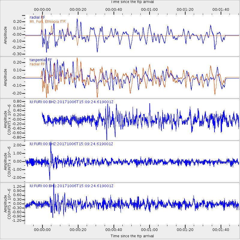
FURI Mt. Furi, Ethiopia - Earthquake Result Viewer
*The percent match for this event was below the threshold and hence no stack was calculated.
| Earthquake location: |
Near East Coast Of Honshu, Japan |
| Earthquake latitude/longitude: |
37.1/141.2 |
| Earthquake time(UTC): |
2017/10/06 (279) 14:56:40 GMT |
| Earthquake Depth: |
47 km |
| Earthquake Magnitude: |
5.4 Mww |
| Earthquake Catalog/Contributor: |
NEIC PDE/us |
|
| Network: |
IU Global Seismograph Network (GSN - IRIS/USGS) |
| Station: |
FURI Mt. Furi, Ethiopia |
| Lat/Lon: |
8.90 N/38.68 E |
| Elevation: |
2570 m |
|
| Distance: |
94.5 deg |
| Az: |
284.61 deg |
| Baz: |
51.533 deg |
| Ray Param: |
$rayparam |
*The percent match for this event was below the threshold and hence was not used in the summary stack. |
|
| Radial Match: |
60.855995 % |
| Radial Bump: |
400 |
| Transverse Match: |
61.11992 % |
| Transverse Bump: |
400 |
| SOD ConfigId: |
2364251 |
| Insert Time: |
2017-10-20 14:58:47.230 +0000 |
| GWidth: |
2.5 |
| Max Bumps: |
400 |
| Tol: |
0.001 |
|
Signal To Noise
| Channel | StoN | STA | LTA |
| IU:FURI:00:BHZ:20171006T15:09:24.619001Z | 3.7246053 | 7.1389655E-7 | 1.916704E-7 |
| IU:FURI:00:BH1:20171006T15:09:24.619001Z | 1.0929335 | 1.8402073E-7 | 1.6837322E-7 |
| IU:FURI:00:BH2:20171006T15:09:24.619001Z | 1.4065435 | 1.6343046E-7 | 1.16192965E-7 |
| Arrivals |
| Ps | |
| PpPs | |
| PsPs/PpSs | |


