You are here: Home > Network List > GE - GEOFON Stations List
> Station RGN GRSN/GEOFON Station Ruegen, Germany > Earthquake Result Viewer
RGN GRSN/GEOFON Station Ruegen, Germany - Earthquake Result Viewer
| Earthquake location: |
Myanmar |
| Earthquake latitude/longitude: |
26.9/97.2 |
| Earthquake time(UTC): |
2000/06/07 (159) 21:46:55 GMT |
| Earthquake Depth: |
33 km |
| Earthquake Magnitude: |
6.3 MB, 6.5 MS, 6.4 MW, 6.4 MW |
| Earthquake Catalog/Contributor: |
WHDF/NEIC |
|
| Network: |
GE GEOFON |
| Station: |
RGN GRSN/GEOFON Station Ruegen, Germany |
| Lat/Lon: |
54.55 N/13.32 E |
| Elevation: |
15 m |
|
| Distance: |
65.1 deg |
| Az: |
320.321 deg |
| Baz: |
78.246 deg |
| Ray Param: |
0.058412597 |
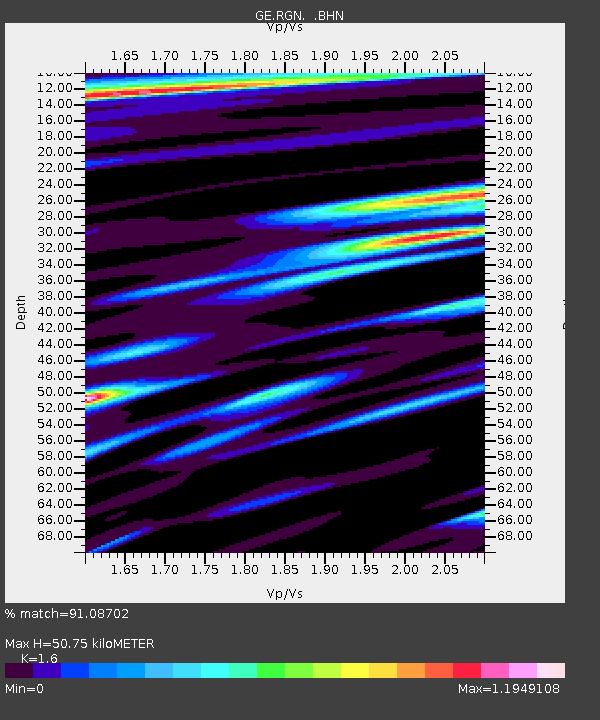
| Estimated Moho Depth: |
50.75 km |
| Estimated Crust Vp/Vs: |
1.60 |
| Assumed Crust Vp: |
6.1 km/s |
| Estimated Crust Vs: |
3.812 km/s |
| Estimated Crust Poisson's Ratio: |
0.18 |
|
| Radial Match: |
91.08702 % |
| Radial Bump: |
400 |
| Transverse Match: |
80.46222 % |
| Transverse Bump: |
400 |
| SOD ConfigId: |
3744 |
| Insert Time: |
2010-03-09 05:07:05.783 +0000 |
| GWidth: |
2.5 |
| Max Bumps: |
400 |
| Tol: |
0.001 |
|

Signal To Noise
| Channel | StoN | STA | LTA |
| GE:RGN: :BHN:20000607T21:57:02.753027Z | 1.1172091 | 7.0221495E-7 | 6.2854394E-7 |
| GE:RGN: :BHE:20000607T21:57:02.753027Z | 1.3091073 | 9.995946E-7 | 7.6356963E-7 |
| GE:RGN: :BHZ:20000607T21:57:02.753027Z | 2.0343084 | 1.1131203E-6 | 5.4717384E-7 |
| Arrivals |
| Ps | 5.2 SECOND |
| PpPs | 21 SECOND |
| PsPs/PpSs | 26 SECOND |


