You are here: Home > Network List > IU - Global Seismograph Network (GSN - IRIS/USGS) Stations List
> Station POHA Pohakuloa, Hawaii, USA > Earthquake Result Viewer
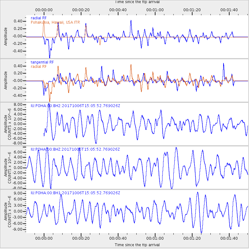
POHA Pohakuloa, Hawaii, USA - Earthquake Result Viewer
*The percent match for this event was below the threshold and hence no stack was calculated.
| Earthquake location: |
Near East Coast Of Honshu, Japan |
| Earthquake latitude/longitude: |
37.1/141.2 |
| Earthquake time(UTC): |
2017/10/06 (279) 14:56:40 GMT |
| Earthquake Depth: |
47 km |
| Earthquake Magnitude: |
5.4 Mww |
| Earthquake Catalog/Contributor: |
NEIC PDE/us |
|
| Network: |
IU Global Seismograph Network (GSN - IRIS/USGS) |
| Station: |
POHA Pohakuloa, Hawaii, USA |
| Lat/Lon: |
19.76 N/155.53 W |
| Elevation: |
1990 m |
|
| Distance: |
57.3 deg |
| Az: |
89.031 deg |
| Baz: |
301.922 deg |
| Ray Param: |
$rayparam |
*The percent match for this event was below the threshold and hence was not used in the summary stack. |
|
| Radial Match: |
56.015102 % |
| Radial Bump: |
400 |
| Transverse Match: |
69.856705 % |
| Transverse Bump: |
400 |
| SOD ConfigId: |
2364251 |
| Insert Time: |
2017-10-20 14:58:57.550 +0000 |
| GWidth: |
2.5 |
| Max Bumps: |
400 |
| Tol: |
0.001 |
|
Signal To Noise
| Channel | StoN | STA | LTA |
| IU:POHA:00:BHZ:20171006T15:05:52.769026Z | 2.2824323 | 5.462814E-6 | 2.3934178E-6 |
| IU:POHA:00:BH1:20171006T15:05:52.769026Z | 0.67836773 | 2.088329E-6 | 3.0784618E-6 |
| IU:POHA:00:BH2:20171006T15:05:52.769026Z | 0.8958132 | 3.1298014E-6 | 3.4938103E-6 |
| Arrivals |
| Ps | |
| PpPs | |
| PsPs/PpSs | |


