You are here: Home > Network List > GE - GEOFON Stations List
> Station RGN GRSN/GEOFON Station Ruegen, Germany > Earthquake Result Viewer
RGN GRSN/GEOFON Station Ruegen, Germany - Earthquake Result Viewer
| Earthquake location: |
Kuril Islands |
| Earthquake latitude/longitude: |
43.0/146.8 |
| Earthquake time(UTC): |
2000/01/28 (028) 14:21:07 GMT |
| Earthquake Depth: |
61 km |
| Earthquake Magnitude: |
6.7 MB, 6.6 MS, 6.8 MW, 6.8 ME |
| Earthquake Catalog/Contributor: |
WHDF/NEIC |
|
| Network: |
GE GEOFON |
| Station: |
RGN GRSN/GEOFON Station Ruegen, Germany |
| Lat/Lon: |
54.55 N/13.32 E |
| Elevation: |
15 m |
|
| Distance: |
75.0 deg |
| Az: |
334.062 deg |
| Baz: |
33.392 deg |
| Ray Param: |
0.05183153 |
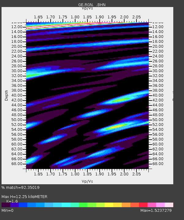
| Estimated Moho Depth: |
12.25 km |
| Estimated Crust Vp/Vs: |
1.60 |
| Assumed Crust Vp: |
6.1 km/s |
| Estimated Crust Vs: |
3.812 km/s |
| Estimated Crust Poisson's Ratio: |
0.18 |
|
| Radial Match: |
92.35019 % |
| Radial Bump: |
400 |
| Transverse Match: |
78.7465 % |
| Transverse Bump: |
400 |
| SOD ConfigId: |
3744 |
| Insert Time: |
2010-03-09 05:07:12.223 +0000 |
| GWidth: |
2.5 |
| Max Bumps: |
400 |
| Tol: |
0.001 |
|

Signal To Noise
| Channel | StoN | STA | LTA |
| GE:RGN: :BHN:20000128T14:32:11.316013Z | 2.8977625 | 2.531182E-6 | 8.7349537E-7 |
| GE:RGN: :BHE:20000128T14:32:11.316013Z | 1.390062 | 1.6344144E-6 | 1.1757853E-6 |
| GE:RGN: :BHZ:20000128T14:32:11.316013Z | 13.172458 | 1.0870942E-5 | 8.2527816E-7 |
| Arrivals |
| Ps | 1.2 SECOND |
| PpPs | 5.1 SECOND |
| PsPs/PpSs | 6.3 SECOND |


