You are here: Home > Network List > GE - GEOFON Stations List
> Station RGN GRSN/GEOFON Station Ruegen, Germany > Earthquake Result Viewer
RGN GRSN/GEOFON Station Ruegen, Germany - Earthquake Result Viewer
| Earthquake location: |
Hokkaido, Japan Region |
| Earthquake latitude/longitude: |
41.0/142.3 |
| Earthquake time(UTC): |
2001/08/13 (225) 20:11:23 GMT |
| Earthquake Depth: |
38 km |
| Earthquake Magnitude: |
6.0 MB, 6.3 MS, 6.4 MW, 6.3 ME |
| Earthquake Catalog/Contributor: |
WHDF/NEIC |
|
| Network: |
GE GEOFON |
| Station: |
RGN GRSN/GEOFON Station Ruegen, Germany |
| Lat/Lon: |
54.55 N/13.32 E |
| Elevation: |
15 m |
|
| Distance: |
75.3 deg |
| Az: |
332.078 deg |
| Baz: |
37.439 deg |
| Ray Param: |
0.051728662 |
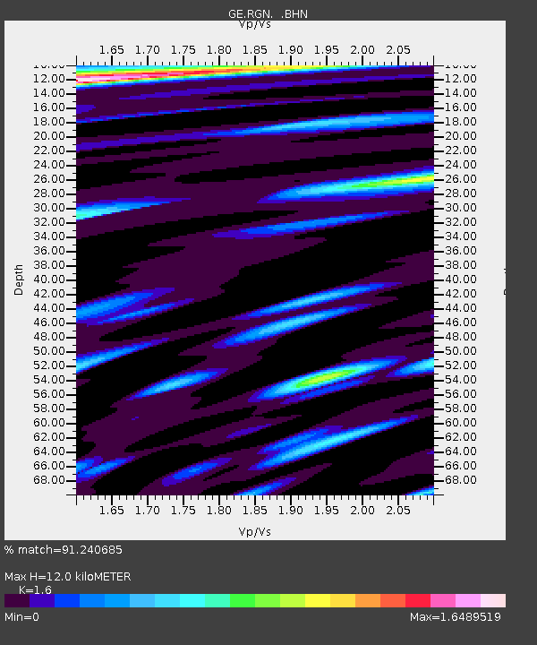
| Estimated Moho Depth: |
12.0 km |
| Estimated Crust Vp/Vs: |
1.60 |
| Assumed Crust Vp: |
6.1 km/s |
| Estimated Crust Vs: |
3.812 km/s |
| Estimated Crust Poisson's Ratio: |
0.18 |
|
| Radial Match: |
91.240685 % |
| Radial Bump: |
400 |
| Transverse Match: |
83.32289 % |
| Transverse Bump: |
400 |
| SOD ConfigId: |
20082 |
| Insert Time: |
2010-03-09 05:07:20.264 +0000 |
| GWidth: |
2.5 |
| Max Bumps: |
400 |
| Tol: |
0.001 |
|

Signal To Noise
| Channel | StoN | STA | LTA |
| GE:RGN: :BHN:20010813T20:22:31.444006Z | 3.0196764 | 1.1388729E-6 | 3.7715066E-7 |
| GE:RGN: :BHE:20010813T20:22:31.444006Z | 2.123799 | 9.5264966E-7 | 4.4855923E-7 |
| GE:RGN: :BHZ:20010813T20:22:31.444006Z | 12.166242 | 3.8564244E-6 | 3.1697746E-7 |
| Arrivals |
| Ps | 1.2 SECOND |
| PpPs | 5.0 SECOND |
| PsPs/PpSs | 6.2 SECOND |


