You are here: Home > Network List > CI - Caltech Regional Seismic Network Stations List
> Station MPM Manuel Prospect Mine, California, USA > Earthquake Result Viewer
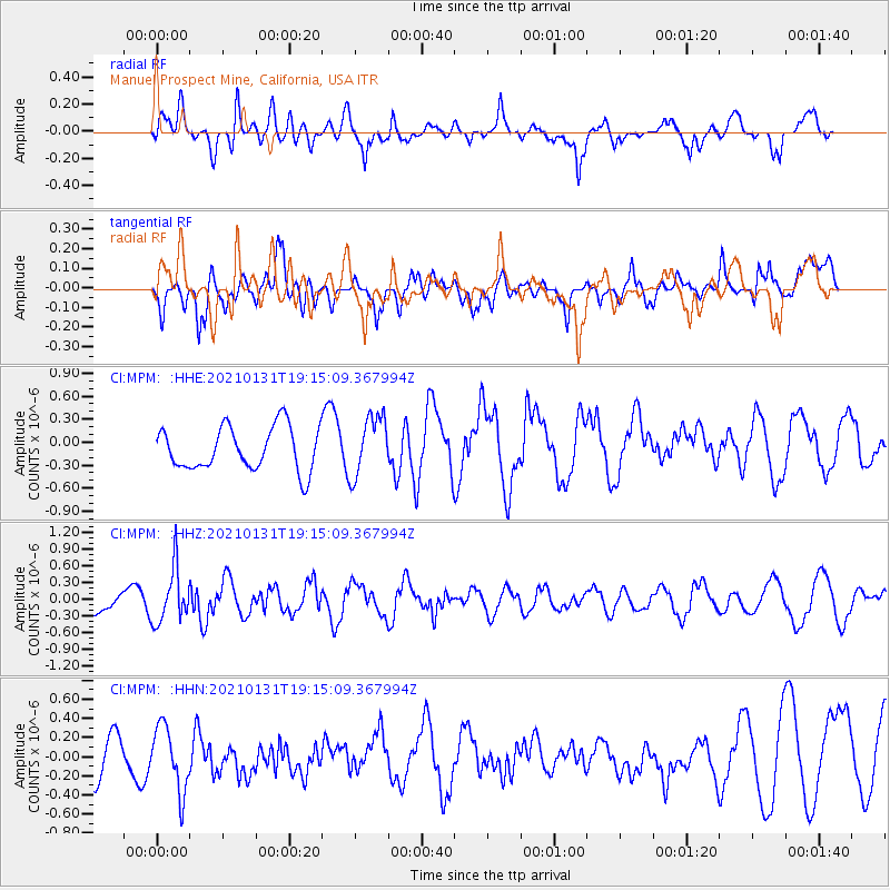
MPM Manuel Prospect Mine, California, USA - Earthquake Result Viewer
*The percent match for this event was below the threshold and hence no stack was calculated.
| Earthquake location: |
Guyana |
| Earthquake latitude/longitude: |
2.6/-59.6 |
| Earthquake time(UTC): |
2021/01/31 (031) 19:05:15 GMT |
| Earthquake Depth: |
9.7 km |
| Earthquake Magnitude: |
5.7 Mww |
| Earthquake Catalog/Contributor: |
NEIC PDE/us |
|
| Network: |
CI Caltech Regional Seismic Network |
| Station: |
MPM Manuel Prospect Mine, California, USA |
| Lat/Lon: |
36.06 N/117.49 W |
| Elevation: |
185 m |
|
| Distance: |
62.8 deg |
| Az: |
309.503 deg |
| Baz: |
107.967 deg |
| Ray Param: |
$rayparam |
*The percent match for this event was below the threshold and hence was not used in the summary stack. |
|
| Radial Match: |
41.985245 % |
| Radial Bump: |
400 |
| Transverse Match: |
56.084076 % |
| Transverse Bump: |
400 |
| SOD ConfigId: |
23341671 |
| Insert Time: |
2021-02-14 20:14:13.893 +0000 |
| GWidth: |
2.5 |
| Max Bumps: |
400 |
| Tol: |
0.001 |
|
Signal To Noise
| Channel | StoN | STA | LTA |
| CI:MPM: :HHZ:20210131T19:15:09.367994Z | 2.3086693 | 4.836317E-7 | 2.0948504E-7 |
| CI:MPM: :HHN:20210131T19:15:09.367994Z | 1.8449322 | 3.442318E-7 | 1.8658235E-7 |
| CI:MPM: :HHE:20210131T19:15:09.367994Z | 1.4049624 | 3.954048E-7 | 2.8143444E-7 |
| Arrivals |
| Ps | |
| PpPs | |
| PsPs/PpSs | |


