You are here: Home > Network List > IW - Intermountain West Stations List
> Station MOOW Moose Ponds, Wyoming, USA > Earthquake Result Viewer
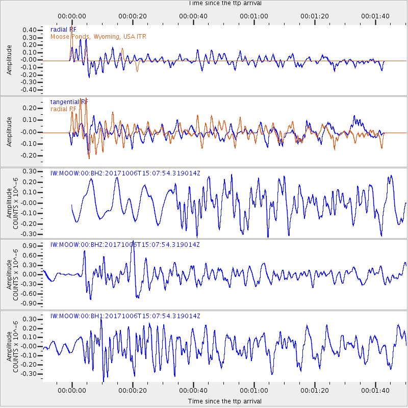
MOOW Moose Ponds, Wyoming, USA - Earthquake Result Viewer
*The percent match for this event was below the threshold and hence no stack was calculated.
| Earthquake location: |
Near East Coast Of Honshu, Japan |
| Earthquake latitude/longitude: |
37.1/141.2 |
| Earthquake time(UTC): |
2017/10/06 (279) 14:56:40 GMT |
| Earthquake Depth: |
47 km |
| Earthquake Magnitude: |
5.4 Mww |
| Earthquake Catalog/Contributor: |
NEIC PDE/us |
|
| Network: |
IW Intermountain West |
| Station: |
MOOW Moose Ponds, Wyoming, USA |
| Lat/Lon: |
43.75 N/110.74 W |
| Elevation: |
2128 m |
|
| Distance: |
76.5 deg |
| Az: |
45.131 deg |
| Baz: |
308.565 deg |
| Ray Param: |
$rayparam |
*The percent match for this event was below the threshold and hence was not used in the summary stack. |
|
| Radial Match: |
69.75278 % |
| Radial Bump: |
400 |
| Transverse Match: |
53.68869 % |
| Transverse Bump: |
400 |
| SOD ConfigId: |
2364251 |
| Insert Time: |
2017-10-20 14:59:13.792 +0000 |
| GWidth: |
2.5 |
| Max Bumps: |
400 |
| Tol: |
0.001 |
|
Signal To Noise
| Channel | StoN | STA | LTA |
| IW:MOOW:00:BHZ:20171006T15:07:54.319014Z | 2.8459597 | 2.504882E-7 | 8.801537E-8 |
| IW:MOOW:00:BH1:20171006T15:07:54.319014Z | 0.89014995 | 7.9561886E-8 | 8.938032E-8 |
| IW:MOOW:00:BH2:20171006T15:07:54.319014Z | 0.89943016 | 1.100655E-7 | 1.2237248E-7 |
| Arrivals |
| Ps | |
| PpPs | |
| PsPs/PpSs | |


